Haupt's Mill Covered Bridge
|
Haupt's Mill Covered Bridge | |
|
Formerly listed on the U.S. National Register of Historic Places | |
 | |
  | |
| Location | Legislative Route 09061 in Durham, Springfield Township, Pennsylvania |
|---|---|
| Coordinates | 40°34′11″N 75°15′02″W / 40.56972°N 75.25056°WCoordinates: 40°34′11″N 75°15′02″W / 40.56972°N 75.25056°W |
| Area | 0.1 acres (0.040 ha) |
| Built | 1872 |
| Architectural style | Other, Town truss |
| MPS | Covered Bridges of the Delaware River Watershed TR |
| NRHP Reference # | 80003446[1] |
| Significant dates | |
| Added to NRHP | December 1, 1980 |
| Removed from NRHP | June 27, 1986 |
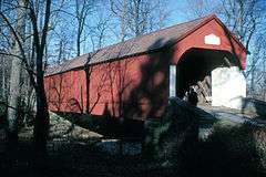
Haupt's Mill Covered Bridge was a historic covered bridge located in Springfield Township, Bucks County, Pennsylvania. It crossed Durham Creek. Built in 1872 in the town truss style, the bridge was 107 feet long and 15 feet wide.[2]
It was added to the National Register of Historic Places on December 1, 1980.[1] It was destroyed by arson in January 1985, and subsequently removed from the National Register of Historic Places.
References
| Wikimedia Commons has media related to Haupt's Mill Covered Bridge. |
- 1 2 National Park Service (2010-07-09). "National Register Information System". National Register of Historic Places. National Park Service.
- ↑ "National Historic Landmarks & National Register of Historic Places in Pennsylvania" (Searchable database). CRGIS: Cultural Resources Geographic Information System. Note: This includes Susan M. Zacher (n.d.). "National Register of Historic Places Inventory Nomination Form: Haupt's Mill Covered Bridge" (PDF). Retrieved 2012-10-29.
This article is issued from Wikipedia - version of the 11/29/2016. The text is available under the Creative Commons Attribution/Share Alike but additional terms may apply for the media files.