Hautes-Alpes
| Hautes-Alpes | |||
|---|---|---|---|
| Department | |||
|
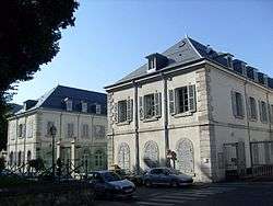
Prefecture building of the Hautes-Alpes department, in Gap | |||
| |||
 Location of Hautes-Alpes in France | |||
| Coordinates: 44°40′N 6°20′E / 44.667°N 6.333°ECoordinates: 44°40′N 6°20′E / 44.667°N 6.333°E | |||
| Country | France | ||
| Region | Provence-Alpes-Côte d'Azur | ||
| Prefecture | Gap | ||
| Subprefectures | Briançon | ||
| Government | |||
| • President of the General Council | Jean-Yves Dusserre (UMP) | ||
| Area1 | |||
| • Total | 5,549 km2 (2,142 sq mi) | ||
| Elevation | 1,665 m (5,463 ft) | ||
| Highest elevation | 4,101 m (13,455 ft) | ||
| Lowest elevation | 470 m (1,540 ft) | ||
| Population (2013) | |||
| • Total | 139,279 | ||
| • Rank | 99th | ||
| • Density | 25/km2 (65/sq mi) | ||
| Time zone | CET (UTC+1) | ||
| • Summer (DST) | CEST (UTC+2) | ||
| Department number | 05 | ||
| Arrondissements | 2 | ||
| Cantons | 15 | ||
| Communes | 168 | ||
| ^1 French Land Register data, which exclude estuaries, and lakes, ponds, and glaciers larger than 1 km2 | |||

Hautes-Alpes (French pronunciation: [ot.z‿alp]; Occitan: Auts Aups) is a department in southeastern France named after the Alps mountain range.
History
Hautes-Alpes is one of the original 83 departments created during the French Revolution on 4 March 1790. It consists of the southeast of the former province of Dauphiné and the north of Provence.
At the time when the department was created, the two mountain communes of La Grave and Villar-d'Arêne successfully campaigned to be included in Hautes-Alpes and not in the neighbouring department of Isère to which they had originally been assigned. This was because they hoped to benefit from the relative autonomy and certain fiscal privileges enjoyed by the region since the fourteenth century under the terms of the Statute of the Briançon Escartons.
Napoleon passed through Gap when he returned to reclaim France after his exile on Elba using what is now known as Route Napoléon.
Geography
The department is surrounded by the following French departments: Alpes-de-Haute-Provence, Drôme, Isère, and Savoie. Italy borders it on the east.
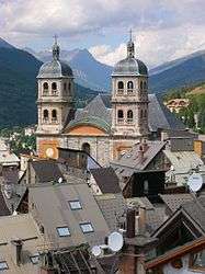
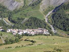
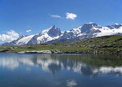
Hautes-Alpes is located in the Alps mountain range. The average elevation is over 1000 m, and the highest elevation is over 4000 m. The only three sizable towns are Gap, Briançon, and Embrun, which was the subprefecture until 1926.
The third highest commune in all of Europe is the village of Saint-Véran. Gap and Briançon are the highest prefecture and subprefecture in France.
The following rivers flow through the department:
The Durance has been dammed to create one of the largest artificial lakes in Western Europe: the Lac de Serre-Ponçon.
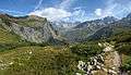
The Queyras valley is located in the eastern part of the department and is noted by many as being an area of outstanding beauty.
Demographics
The inhabitants of the department are called Haut-Alpins.
The extremely mountainous terrain explains the sparse population, which was originally about 120,000. It changed little during the 19th century, but fell to about 85,000 after World War I. Thanks in large part to tourism, the population has risen from 87,436 in 1962 to 121,419 in 1999, principally in the town of Gap.
Politics
The President of the General Council is Jean-Yves Dusserre of the Union for a Popular Movement.
| Party | seats | |
|---|---|---|
| • | Union for a Popular Movement | 10 |
| Socialist Party | 7 | |
| • | Miscellaneous Right | 5 |
| Left Radical Party | 4 | |
| Miscellaneous Left | 3 | |
| • | New Centre | 1 |
Tourism
The tourist industry is largely dependent on skiing in winter. In summer the Alpine scenery and many outdoor activities attract visitors from across Europe(sailing, hiking, climbing and aerial sports such as gliding). The Tour de France passes through the department regularly. This draws many cycling fanatics to cycle the cols and watch the race.
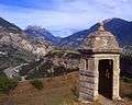 The Alps and the Guil valley seen from Fort Mont-Dauphin
See also
- Cantons of the Hautes-Alpes department
- Communes of the Hautes-Alpes department
- Arrondissements of the Hautes-Alpes department
External links
Hautes-Alpes at DMOZ
- (French) Official Website
- (French) Prefecture website
- (French) General Council webstite
- (French) A village in the French Alps built by Vauban