Hauts-de-France
| Hauts-de-France | |
|---|---|
| Region of France | |
 | |
| Country |
|
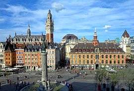
| Prefecture | Lille |
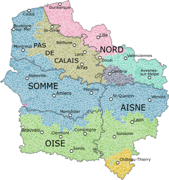
| Departments | |
| Government | |
| • President | Xavier Bertrand (The Republicans) |
| Area | |
| • Total | 31,813 km2 (12,283 sq mi) |
| Population (2012) | |
| • Total | 5,973,098 |
| • Density | 190/km2 (490/sq mi) |
| Time zone | CET (UTC+1) |
| • Summer (DST) | CEST (UTC+2) |
| Website |
www |
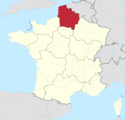
Hauts-de-France[1] (French pronunciation: [o d(ə) fʁɑ̃s], translates to "Upper France" or "the heights of France" in English) is a Region of France created by the territorial reform of French Regions in 2014 by the merger of Nord-Pas-de-Calais and Picardy. The new region came into existence on 1 January 2016, after the regional elections in December 2015.[2] France's Conseil d'État approved Hauts-de-France as the new name of the region on 28 September 2016, effective 30 September 2016.[3]
The region covers an area of more than 31,813 km2 (12,283 sq mi), and with a population of 5,973,098.[4]
Toponymy
The region's interim name Nord-Pas-de-Calais-Picardie was a hyphenated placename, created by hyphenating the merged regions' names—Nord-Pas-de-Calais and Picardie—in alphabetical order.[5]
On 14 March 2016, well ahead of the 1 July deadline, the Regional council decided on Hauts-de-France as the region's permanent name,.[1][5] The provisional name of the region will be retired on 30 September 2016, when the new name of the region, Hauts-de-France, takes effect.[3]
Like the name Région Grand Est (and, until 2015, the name Région Centre), the name Région Hauts-de-France contains no reference whatsoever to the area's history or identity, but merely describes its geographical location within metropolitan France.
Geography
The region borders Belgium (Flanders and Wallonia) to the northeast, the English Channel and the United Kingdom (England) to the northwest, as well as the French regions of Grand Est to the southeast, Île-de-France to the south, and Normandy to the southwest.
Major communities
.JPG)
- Lille (227,560; region prefecture)
- Amiens (133,448)
- Roubaix (94,713)
- Tourcoing (91,923)
- Dunkirk (90,995)
- Calais (72,589)
- Villeneuve-d'Ascq (62,308)
- Saint-Quentin (55,978)
- Beauvais (54,289)
- Valenciennes (42,989)
See also
References
- 1 2 Regional council votes for "Hauts-de-France", La Voix du Nord, 14 March 2016
- ↑ "La carte à 13 régions définitivement adoptée" (in French). Le Monde. Agence France-Presse. 17 December 2014. Retrieved 13 January 2015.
- 1 2 Décret n° 2016-1265 du 28 septembre 2016 portant fixation du nom et du chef-lieu de la région Hauts-de-France (in French)
- ↑ "Insee - Populations légales 2012 - Populations légales 2012 des régions". Insee. Retrieved 16 January 2015.
- 1 2 Loi n° 2015-29 du 16 janvier 2015 relative à la délimitation des régions, aux élections régionales et départementales et modifiant le calendrier électoral (in French)
External links
Coordinates: 49°55′14″N 2°42′11″E / 49.9206°N 2.7030°E