Hawaiian Volcano Observatory
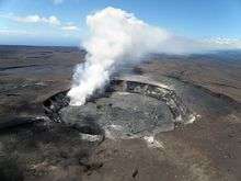
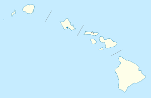
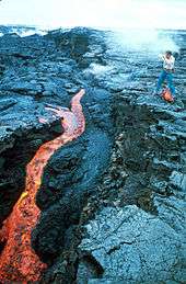
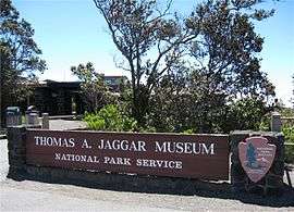
The Hawaiian Volcano Observatory (HVO) is a volcano observatory located at Uwekahuna Bluff on the rim of Kīlauea Caldera on the Island of Hawaiʻi. The observatory monitors four active Hawaiian volcanoes: Kīlauea, Mauna Loa, Hualālai, and Haleakalā. Because Kīlauea and Mauna Loa are significantly more active than Hualālai and Haleakalā, much of the observatory's research is concentrated on the former two mountains. The observatory has a worldwide reputation as a leader in the study of active volcanism. Due to the relatively non-explosive nature of Hawaiian volcanic eruptions, scientists can study on-going eruptions in proximity without being in extreme danger. Located at the main site is the public Thomas A. Jaggar Museum.
History
|
Whitney Seismograph Vault No. 29 | |
 | |
| Nearest city | Volcano, Hawaii |
|---|---|
| Coordinates | 19°25′45″N 155°15′31″W / 19.42917°N 155.25861°WCoordinates: 19°25′45″N 155°15′31″W / 19.42917°N 155.25861°W |
| Area | 18 feet (5.5 m) by 17.5 feet (5.3 m) |
| Built | 1912 |
| NRHP Reference # | 74000292[1] |
| Added to NRHP | July 24, 1974 |
Besides the oral history of Ancient Hawaiians, several early explorers left records of observations. Rev. William Ellis kept a journal of his 1823 missionary tour,[2] and Titus Coan documented eruptions through 1881.[3] Scientists often debated the accuracy of these descriptions. When prominent geologist Thomas Jaggar of the Massachusetts Institute of Technology gave a lecture in Honolulu in 1909, he was approached by businessman Lorrin A. Thurston (grandson of Asa Thurston who was on the 1823 missionary tour) about building a full-time scientific observatory at Kīlauea. The Hawaiian Volcano Research Association was formed by local businessmen for its support. George Lycurgus, who owned the Volcano House at the edge of the main caldera, proposed a site adjacent to his hotel and restaurant.
In 1911 and 1912, small cabins were built on the floor of the caldera next to the main active vent of Halemaʻumaʻu, but these were hard to maintain.[4] MIT added $25,000 in support in 1912 from the estate of Edward and Caroline Whitney to build a more permanent facility. The first instruments were housed in a cellar next to the Volcano House called the Whitney Laboratory of Seismology.[5] Inmates from a nearby prison camp had excavated through 5.5 feet (1.7 m) of volcanic ash. Massive reinforced concrete walls supported a small building built on top of the structure. Professor Fusakichi Omori of Japan, now best known for his study of aftershocks, designed the original seismometers. This seismograph vault (building number 29 on a site inventory) is state historic site 10-52-5506,[6] and was added to the National Register of Historic Places on July 24, 1974 as site 74000292.[7]
From 1912 until 1919, the observatory was run by Jaggar personally. Many important events were recorded, although as pioneers, the team often ran into major problems. For example, in 1913 an earthquake opened a crack in a wall and water seeped in. The windows meant to admit natural light caused the vault to heat up in the intense tropical sun.[4] The opening of the national park in 1916 (at the urging of Thurston) brought more visitors to bother the scientists, but also park rangers who would take over public lectures. The prison that had supplied laborers was replaced by the Kīlauea Military Camp.[8]
In 1919, Jaggar convinced the National Weather Service to take over operations at the observatory. In 1924, the observatory was taken over by the United States Geological Survey and it has been run by the USGS ever since (except for a brief period during the Great Depression, when the observatory was run by the National Park Service).[9] When the Volcano House hotel burned to the ground in 1940, the old building was torn down (although the instruments in the vault continued to be used until 1961).
George Lycurgus convinced friends in Washington D.C. (many of whom had stayed in the Volcano House) to build a larger building farther back from the cliff, so he could built a new larger hotel at the former HVO site. By 1942, the "Volcano Observatory and Naturalist Building" was designated number 41 on the park inventory. However, with the advent of World War II, it was commandeered as a military headquarters. HVO was allowed to use building 41 from October 1942 to September 1948, when it became the park headquarters (and still is today, after several additions).[4]
About two miles west, in an area known as Uwekahuna, a "National Park Museum and Lecture Hall" had been built in 1927. The name means roughly "the priest wept" in the Hawaiian Language, which indicates it might have been used to make offerings in the past.[10] The HVO moved there in 1948 after some remodeling of the building. This site was even closer to the main vent of Kīlauea. In 1985 a larger building was built for the observatory adjacent to the old lecture hall, which was turned back into a museum and public viewing site.
Hawaiian Volcano Observatory (HVO)
- HVO Directors
- 1912 to 1940, Thomas A. Jaggar, Jr. (1871–1953)
- 1940 to 1951, Ruy H. Finch
- 1951 to 1955, Gordon A. MacDonald (1911–1978)
- 1956 to 1958, Jerry P. Eaton
- HVO Scientists-in-Charge
- 1958 to 1960, Kiguma J. Murata
- 1960 to 1961, Jerry P. Eaton
- 1961 to 1962, Donald H. Richter
- 1962 to 1963, James G. Moore
- 1964 to 1970, Howard A. Powers
- 1970 to 1975, Donald W. Peterson
- 1975 to 1976, Robert I. Tilling
- 1976 to 1978, Gordon P. Eaton
- 1978 to 1979, Donald W. Peterson
- 1979 to 1984, Robert W. Decker (1927–2005)
- 1984 to 1991, Thomas L. Wright
- 1991 to 1996, David A. Clague
- 1996 to 1997, Margaret T. Mangan
- 1997 to 2004, Donald A. Swanson
- 2004 to 2015, James P. Kauahikaua
- 2015 to 20??, Christina A. Neal
Present day operations
Modern electronic equipment now monitors earthquakes from several sites.[11] This information is provided immediately over the Internet, as is live coverage of ongoing eruptions from several webcams. Another important function of HVO is to monitor the sulphur emissions that produce the volcanic pollution condition known as vog. The observatory advises the park service when to close areas due to this and other volcanic hazards.[12]
While the main Observatory building itself is not open to the public, the adjacent Thomas A. Jaggar Museum includes interpretive exhibits on the work done at the observatory. The exhibits range from general information on volcanoes and lava to the scientific equipment and clothing used by volcanologists. Some of the museum's windows provide a sheltered view of the Kīlauea Caldera and Halemaʻumaʻu Crater. A public observation deck overlooking Kīlauea provides spectacular views.[13] It a popular destination within Hawaii Volcanoes National Park, located at coordinates 19°25′12″N 155°17′16.8″W / 19.42000°N 155.288000°W, on Crater Rim Drive west from the Visitor Center.
References
- ↑ National Park Service (2009-03-13). "National Register Information System". National Register of Historic Places. National Park Service.
- ↑ William Ellis (1825). "A journal of a tour around Hawai'i, the largest of the Sandwich Islands". Crocker and Brewster, New York, republished 2004, Mutual Publishing, Honolulu: 282. ISBN 1-56647-605-4.
- ↑ Coan, Titus (1882). Life in Hawaii. New York: Anson Randolph & Company. ISBN 0-8370-6036-2.
- 1 2 3 "Buildings and Facilities". United States Geological Survey. Retrieved 2009-06-24.
- ↑ Russell A. Apple. "HVO History". United States Geological Survey HVO web site. Retrieved 2009-07-11.
- ↑ Historic Places in Hawaii County on official state web site
- ↑ Russell A. Apple (1972). "Whitney Seismograph Vault #29 nomination form" (PDF). National Register of Historic Places. National Park Service.
- ↑ "About KMC". Kīlauea Military Camp. Retrieved 2009-06-25.
- ↑ "Thomas Jaggar, HVO's founder". Hawaiian Volcano Observatory's Volcano Watch. March 21, 1997. Retrieved 2009-06-21.
- ↑ "Lookup of "Uwekahuna"". on Hawaiian Place Names web site. Retrieved 2009-06-25.
- ↑ "Earthquakes in Hawaii". USGS Hawaiian Volcano Observatory Network. Retrieved 2009-06-25.
- ↑ "Closed Areas and Advisories". National Park Service Hawaii Volcanoes National Park web site.
- ↑ "Jaggar Museum". National Park Service web site. Retrieved 2009-06-21.
Further reading
- Volcanism in Hawaii: Papers to Commemorate the 75th Anniversary of the Founding of the Hawaiian Volcano Observatory (HVO)
- Robert W. Decker; Thomas L. Wright; Peter H. Stauffer, eds. (1987). Volcanism in Hawaii. Volume 1: Physiography, Tectonics, and Submarine Geology. Geology of the Island of Hawaii. Petrogenesis and Volcanic Gases. U. S. Geological Survey Professional Paper 1350 (397 MB PDF).
- Thomas L. Wright; Peter H. Stauffer; Robert W. Decker, eds. (1987). Volcanism in Hawaii. Volume 2: Structure, Dynamics, History of Investigations of Hawaiian Volcanism. U.S. Geological Survey Professional Paper 1350 (339 MB PDF).
- Volcanism in Hawaii: Paper to Commemorate the 100th Anniversary of the Founding of the Hawaiian Volcano Observatory (HVO)
- Babb, J.L., Kauahikaua, J.P., and Tilling, R.I. (2011). "The story of the Hawaiian Volcano Observatory – A remarkable first 100 years of tracking eruptions and earthquakes: U.S. Geological Survey General Information Product 135": 60.
External links
- Hawaiian Volcano Observatory official web site
- Current SO2 conditions from Hawaii Volcanoes National Park
- Live web cams from HVO of Halemaʻumaʻu and Puʻu Ōʻō vents
| Topics | |
|---|---|
| Lists by states |
|
| Lists by insular areas | |
| Lists by associated states | |
| Other areas | |
| |
Hawaiian volcanism topics (list) | ||
|---|---|---|
| Windward Isles |  | |
| Leeward Isles | ||
| Emperor Seamounts | ||
| Topics | ||