Hawthorne Circle
| Hawthorne Interchange | |
|---|---|
| Hawthorne Circle | |
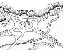 A map of the interchange's former iteration as a traffic circle | |
| Location | |
| Hawthorne, New York, United States | |
| Coordinates: | 41°6′34.3″N 73°48′6.4″W / 41.109528°N 73.801778°WCoordinates: 41°6′34.3″N 73°48′6.4″W / 41.109528°N 73.801778°W |
| Roads at junction: |
|
| Construction | |
| Type: |
Three-level partial stack interchange (former traffic circle) |
| Spans: | 4 |
| Lanes: | 10 |
| Constructed: |
1929-1931, 1971 by WCPC and NYSDOT |
| Opened: |
1931 (as a circle) 1971 (as an interchange)[1] |
| Maintained by: | NYSDOT |
Hawthorne Circle was a notably dangerous traffic circle located in Hawthorne, New York, United States until 1971 when it was replaced with a three-level interchange.[1] The circle once connected two busy highways, the Taconic State Parkway and the Saw Mill River Parkway.[2] It also accessed to the Bronx River Parkway by way a 2.6-mile (4.18 km) segment of the Taconic Parkway. The Sprain Brook Parkway, whose northern terminus lies just south of the circle, was not completed until 1980, eight years after the circle was converted to an interchange.
With over 67,000 cars passing through the area daily, a traffic circle would be even more dangerous today than it was in 1971.
For many years after the circle was eliminated, the Hawthorne Interchange was sometimes misleadingly referred to by its former name, especially in radio traffic reports.
References
- 1 2 National Environmental Tidal Research, LLC (1971). "HistoricAerials by NETROnline". Retrieved January 14, 2016.
- ↑ File:Taconic State Parkway, Poughkeepsie, Dutchess County, NY HAER NY,14-POKEP.V,1- (sheet 8 of 13).tif (Library of Congress Prints and Photographs Division Washington, D.C.)
External links
![]() Media related to Hawthorne Circle at Wikimedia Commons
Media related to Hawthorne Circle at Wikimedia Commons