Hedgehope Hill
| Hedgehope Hill | |
|---|---|
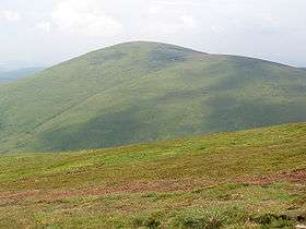 Hedgehope Hill from Scald Hill | |
| Highest point | |
| Elevation | 714 m (2,343 ft) |
| Listing | Hewitt |
| Coordinates | 55°28′19″N 2°05′25″W / 55.47195°N 2.09039°WCoordinates: 55°28′19″N 2°05′25″W / 55.47195°N 2.09039°W |
| Geography | |
 Hedgehope Hill Hedgehope Hill in Northumberland | |
| Location | Cheviot Hills, Northumberland |
| OS grid | NT9438619796 |
| Topo map | OS Landranger 80 |
Hedgehope Hill is a mountain in the Cheviot Hills of North Northumberland in North East England and categorised as a Hewitt.
At a height of 714 metres (2,343 ft) and a distance of about 3 miles (4.8 km) from the Scottish border, it is best climbed from Langleeford in the Harthorpe Valley, over which it looms. A slightly gentler climb, though a longer distance, is from Linhope in the Breamish valley, approaching from the south east. An alternative route to the summit could involve a long day's climb of both the Cheviot and Hedgehope Hill starting and finishing at Langleeford. It is a steep climb from any approach, best reserved for fitter walkers though the steepest inclines are not long in distance.
Hedgehope has steeper sides than the taller but flatter-topped Cheviot and affords excellent views on all sides. On a clear day, views stretch to Blyth down the coastline up to 40 miles (60 km) away.