Heeze-Leende
| Heeze-Leende | |||
|---|---|---|---|
| Municipality | |||
|
| |||
| |||
.svg.png) Location in North Brabant | |||
| Coordinates: 51°23′N 5°35′E / 51.383°N 5.583°ECoordinates: 51°23′N 5°35′E / 51.383°N 5.583°E | |||
| Country | Netherlands | ||
| Province | North Brabant | ||
| Established | 1 January 1997[1] | ||
| Government[2] | |||
| • Body | Municipal council | ||
| • Mayor | Paul Verhoeven (VVD) | ||
| Area[3] | |||
| • Total | 105.04 km2 (40.56 sq mi) | ||
| • Land | 104.00 km2 (40.15 sq mi) | ||
| • Water | 1.04 km2 (0.40 sq mi) | ||
| Elevation[4] | 23 m (75 ft) | ||
| Population (May 2014)[5] | |||
| • Total | 15,466 | ||
| • Density | 149/km2 (390/sq mi) | ||
| Time zone | CET (UTC+1) | ||
| • Summer (DST) | CEST (UTC+2) | ||
| Postcode | 5590–5595, 6029 | ||
| Area code | 040 | ||
| Website |
www | ||
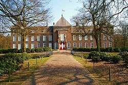


Heeze-Leende (![]() pronunciation ) is a municipality in the southern Netherlands, near Eindhoven. It is known for Heeze Castle (Kasteel Heeze).
pronunciation ) is a municipality in the southern Netherlands, near Eindhoven. It is known for Heeze Castle (Kasteel Heeze).
The spoken language is "Heeze-en-Leendes", a distinct dialect within the East Brabantian dialect group and is very similar of colloquial Dutch.
Population centres
Topography
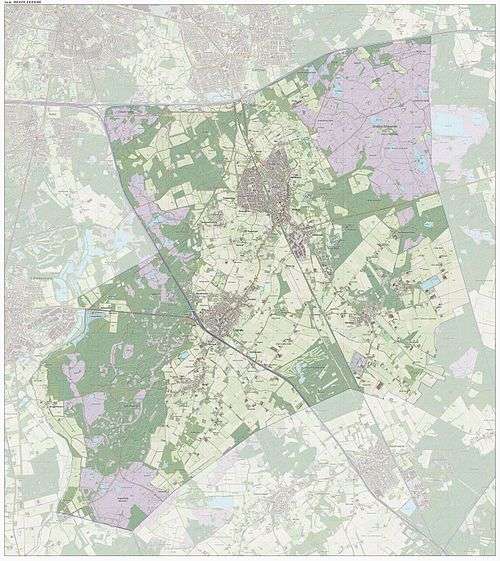
Dutch Topographic map of the municipality of Heeze-Leende, June 2015
References
- ↑ "Gemeentelijke indeling op 1 januari 1997" [Municipal divisions on 1 January 1997]. cbs.nl (in Dutch). CBS. Retrieved 28 May 2014.
- ↑ "Wie is wie" [Who is who] (in Dutch). Gemeente Heeze-Leende. Retrieved 28 May 2014.
- ↑ "Kerncijfers wijken en buurten" [Key figures for neighbourhoods]. CBS Statline (in Dutch). CBS. 2 July 2013. Retrieved 12 March 2014.
- ↑ "Postcodetool for 5591HS". Actueel Hoogtebestand Nederland (in Dutch). Het Waterschapshuis. Retrieved 28 May 2014.
- ↑ "Bevolkingsontwikkeling; regio per maand" [Population growth; regions per month]. CBS Statline (in Dutch). CBS. 26 June 2014. Retrieved 24 July 2014.
External links
 Media related to Heeze-Leende at Wikimedia Commons
- Official website
 |
Eindhoven | Geldrop-Mierlo | | |
| Waalre Valkenswaard |
|
Someren | ||
| ||||
| | ||||
| Hamont-Achel (BE-VLI), Cranendonck |

This article is issued from Wikipedia - version of the 7/23/2015. The text is available under the Creative Commons Attribution/Share Alike but additional terms may apply for the media files.