Helliwell Provincial Park
| Helliwell Provincial Park | |
|---|---|
|
IUCN category II (national park) | |
|
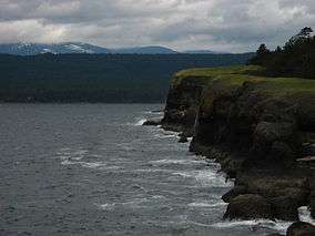
The cliffs of Helliwell Provincial Park | |
| Location | Hornby Island, British Columbia, Canada |
| Nearest city | Courtenay |
| Coordinates | 49°31′00″N 124°36′20″W / 49.51667°N 124.60556°W[1]Coordinates: 49°31′00″N 124°36′20″W / 49.51667°N 124.60556°W[1] |
| Area | 2,872 hectares (7,100 acres)[2] |
| Established | September 16, 1966[1] |
| Governing body | BC Parks |
| http://www.env.gov.bc.ca/bcparks/explore/parkpgs/helliwell/ | |
Helliwell Provincial Park is a provincial park in British Columbia, Canada located on a headland at the southeast end of Hornby Island.
The land, formerly a farm belonging to the Acton family, was donated by Mr. J. L. Helliwell.[3] The park was established by Order in Council 2681 on September 16, 1966 and expanded several times thereafter.[1] Its 2,872 hectares (7,100 acres) now include Flora Islet and part of Lambert Channel.[2]
There are facilities for hiking, canoeing, picnicking, sightseeing, and scuba diving. Restroom facilities consist of four pit toilets.[2]
The park has large old-growth Douglas fir tree and rare Garry oak meadow ecosystems. A trail loops around the bluffs that overlook the Strait of Georgia and links-up with Tribune Bay. The Garry oak meadow ecosystem is one of the many microclimates located within British Columbia and is considered an endangered habitat.[4]
The cliffs in the southern part of the park form a unique microclimate that local community groups are attempting to protect . These cliffs are also nesting areas for the pelagic cormorant.[5]
See also
References
- 1 2 3 4 "Helliwell Park". BC Geographical Names.
- 1 2 3 "Helliwell Provincial Park". Retrieved August 2, 2010.
- ↑ "Fillongley, Tribune Bay, Helliwell, Sandy Island Parks Master Plan" (PDF). 1987. Retrieved August 2, 2010.
- ↑ Pacific Forestry Centre, Canadian Forestry Service Garry Oak Recovery Team Research document, 2005
- ↑ BC Wildlife Watch, Ministry of Environment
External links
- Helliwell Provincial Park – B.C. Ministry of Environment Site
- Tribune Bay Provincial Park – B.C. Ministry of Environment Site
- Helliwell/Tribune Bay Provincial Park – Commercial Site
- Garry Oak Ecosystem – Province of British Columbia Ministry of Environment