Heng, Rogaland
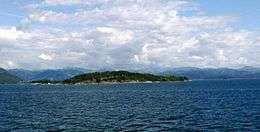 View of the island | |
| Geography | |
|---|---|
| Location | Rogaland, Norway |
| Coordinates | 59°01′14″N 5°53′38″E / 59.0206°N 5.8939°ECoordinates: 59°01′14″N 5°53′38″E / 59.0206°N 5.8939°E |
| Area | 0.6 km2 (0.23 sq mi) |
| Length | 1.3 km (0.81 mi) |
| Width | 800 m (2,600 ft) |
| Highest elevation | 53 m (174 ft) |
| Highest point | Høgabakka |
| Administration | |
| County | Rogaland |
| Municipality | Strand |
Heng is a small island in Strand municipality in Rogaland county, Norway.[1] The 0.6-square-kilometre (150-acre) island lies in the Idsefjorden, about 3 kilometres (1.9 mi) southwest of the village of Tau on the mainland. Heng lies roughly halfway between the islands of Hidle and Idse.
See also
References
- ↑ "Heng, Strand (Rogaland)" (in Norwegian). yr.no. Retrieved 2016-02-03.
This article is issued from Wikipedia - version of the 7/21/2016. The text is available under the Creative Commons Attribution/Share Alike but additional terms may apply for the media files.