Hennepin, Illinois
| Village of Hennepin | |
|---|---|
|
| |
 Location in the state of Illinois | |
| Coordinates: 41°15′10″N 89°20′30″W / 41.25278°N 89.34167°WCoordinates: 41°15′10″N 89°20′30″W / 41.25278°N 89.34167°W | |
| Country | United States |
| State | Illinois |
| County | Putnam |
| Township | Hennepin |
| Incorporated | February 13, 1837 |
| Government | |
| • Mayor | Kevin Coleman |
| • Clerk | Diana Brandstatter |
| • Treasurer | Diana Gibson |
| Area | |
| • Total | 5.63 sq mi (14.6 km2) |
| • Land | 5.26 sq mi (13.6 km2) |
| • Water | 0.36 sq mi (0.9 km2) 6.39% |
| Elevation | 503 ft (153 m) |
| Population (2000) | |
| • Total | 707 |
| • Density | 135.4/sq mi (52.3/km2) |
| Time zone | CST (UTC-6) |
| • Summer (DST) | CDT (UTC-5) |
| ZIP codes | 61327 |
| Website | http://www.villageofhennepin.com |
Hennepin is a village on the Illinois River in Putnam County, Illinois, United States. The population was 757 at the 2010 census, up from 707 in 2000. It is the county seat of Putnam County.[1]
Hennepin is part of the Ottawa–Streator Micropolitan Statistical Area.
History
Hennepin was named for the explorer Louis Hennepin.[2]
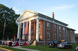
Hennepin's Putnam County Courthouse, built in 1837, was as of 2007 the oldest county courthouse in Illinois still serving its original purpose.[3]
Geography
Hennepin is located at 41°15′24″N 89°19′48″W / 41.25667°N 89.33000°W (41.256712, -89.329899).[4]
According to the 2010 census, Hennepin has a total area of 5.625 square miles (14.57 km2), of which 5.26 square miles (13.62 km2) (or 93.51%) is land and 0.365 square miles (0.95 km2) (or 6.49%) is water.[5]
Demographics
| Historical population | |||
|---|---|---|---|
| Census | Pop. | %± | |
| 1880 | 623 | — | |
| 1890 | 574 | −7.9% | |
| 1900 | 523 | −8.9% | |
| 1910 | 451 | −13.8% | |
| 1920 | 377 | −16.4% | |
| 1930 | 312 | −17.2% | |
| 1940 | 396 | 26.9% | |
| 1950 | 312 | −21.2% | |
| 1960 | 391 | 25.3% | |
| 1970 | 535 | 36.8% | |
| 1980 | 716 | 33.8% | |
| 1990 | 669 | −6.6% | |
| 2000 | 707 | 5.7% | |
| 2010 | 757 | 7.1% | |
| Est. 2015 | 698 | [6] | −7.8% |
As of the census[8] of 2000, there were 707 people, 304 households, and 206 families residing in the village. The population density was 135.4 people per square mile (52.3/km²). There were 334 housing units at an average density of 64.0 per square mile #24.7/km²#. The racial makeup of the village was 97.17% White, 1.13% African American, 0.28% Native American, 0.71% Asian, 0.57% from other races, and 0.14% from two or more races. Hispanic or Latino of any race were 3.82% of the population.
There were 304 households out of which 26.6% had children under the age of 18 living with them, 59.2% were married couples living together, 5.6% had a female householder with no husband present, and 32.2% were non-families. 30.3% of all households were made up of individuals and 16.1% had someone living alone who was 65 years of age or older. The average household size was 2.32 and the average family size was 2.87.
In the village the population was spread out with 20.8% under the age of 18, 9.2% from 18 to 24, 24.6% from 25 to 44, 27.0% from 45 to 64, and 18.4% who were 65 years of age or older. The median age was 42 years. For every 100 females there were 96.4 males. For every 100 females age 18 and over, there were 92.4 males.
The median income for a household in the village was $46,827, and the median income for a family was $56,111. Males had a median income of $48,500 versus $19,231 for females. The per capita income for the village was $23,981. About 2.6% of families and 2.9% of the population were below the poverty line, including 5.6% of those under age 18 and 2.9% of those age 65 or over.
Industry
Because of its location on the Illinois River, Hennepin has a large amount of industry. Mittal Steel operated a large rolling plant on the north edge of town for many years before shutting the plant down in March 2009. Ameren operates a coal-fired power plant near Donnelley Wildlife Area on the western edge of town. There are also Cargill, ADM, and CGB elevators throughout the area. Marquis Energy just opened a 100 million gallon/year ICM/Fagen ethanol plant just north of town in April 2008 as well.
Landmarks
The Dixon Waterfowl Refuge, a privately maintained wetland, is located two miles south of Hennepin.
Notable people
- Albert W. Durley, Wisconsin State Assemblyman and lawyer; was born near Hennepin.[9]
- John Wesley Powell, Civil War era Army second lieutenant, teacher and superintendent of Hennepin schools.[10]
References
| Wikimedia Commons has media related to Hennepin, Illinois. |
- ↑ "Find a County". National Association of Counties. Retrieved 2011-06-07.
- ↑ Gannett, Henry (1905). The Origin of Certain Place Names in the United States. Govt. Print. Off. p. 155.
- ↑ http://www.outfitters.com/illinois/putnam/
- ↑ "US Gazetteer files: 2010, 2000, and 1990". United States Census Bureau. 2011-02-12. Retrieved 2011-04-23.
- ↑ "G001 - Geographic Identifiers - 2010 Census Summary File 1". United States Census Bureau. Retrieved 2015-08-03.
- ↑ "Annual Estimates of the Resident Population for Incorporated Places: April 1, 2010 to July 1, 2015". Retrieved July 2, 2016.
- ↑ "Census of Population and Housing". Census.gov. Retrieved June 4, 2015.
- ↑ "American FactFinder". United States Census Bureau. Retrieved 2008-01-31.
- ↑ 'Wisconsin Blue Book 1907,' Biographical Sketch of Albert W. Durley. pg. 1147
- ↑ http://www.nps.gov/history/history/online_books/geology/publications/inf/74-24/sec1.htm
Municipalities and communities of Putnam County, Illinois, United States | ||
|---|---|---|
| Villages | ||
| Townships | ||
| Unincorporated communities | ||
| Footnotes | ‡This populated place also has portions in an adjacent county or counties | |