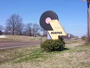
Hernando de Soto Bridge
| Hernando de Soto Bridge | |
|---|---|
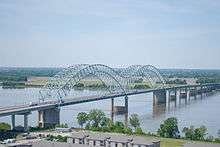 Hernando de Soto Bridge photographed from the Memphis Pyramid | |
| Coordinates | 35°09′10″N 90°03′50″W / 35.15278°N 90.06389°WCoordinates: 35°09′10″N 90°03′50″W / 35.15278°N 90.06389°W |
| Carries |
6 lanes of |
| Crosses | Mississippi River |
| Locale | West Memphis, Arkansas, and Memphis, Tennessee |
| Other name(s) | The M Bridge, Memphis Bridge, Mississippi Bridge, New Bridge |
| Maintained by | TDOT and AHTD |
| ID number | 79I00400001 |
| Characteristics | |
| Design | Through arch bridge |
| Total length | 9,432.6 feet (2,875 m) |
| Width | 90 feet (27 m) |
| Longest span | 900 feet (274 m) each |
| Clearance below | 109 feet (33 m) (varies some due to river level) |
| History | |
| Opened | August 2, 1973 |
| Statistics | |
| Daily traffic | 43,000 (2008) |
The Hernando de Soto Bridge is a through arch bridge carrying Interstate 40 across the Mississippi River between West Memphis, Arkansas, and Memphis, Tennessee. Memphians also call the bridge the "New Bridge",[1] as it is newer than the Memphis & Arkansas Bridge (carrying Interstate 55) downstream, and the "M Bridge", due to its distinctive shape. It is of similar construction to the Sherman Minton Bridge between Louisville, Kentucky, and New Albany, Indiana.
Namesake
The bridge is named for 16th century Spanish explorer Hernando de Soto who explored this stretch of the Mississippi River, and died south of Memphis. His body was believed to have been buried in the Mississippi River after his death (although, according to legend, his body lay at the bottom of Lake Chicot in Arkansas, an oxbow lake of the Mississippi River about 130 miles south of Memphis.)
Incidents
On August 23, 2007, an inspector discovered that a bridge pier on the approach bridge west of the river had settled overnight, and the bridge was subsequently closed to perform a precautionary inspection. The bridge was reopened later that day.[2]
Bridge illumination
At night, the bridge is illuminated by 200 sodium vapor lights along its "M" shape structure. The bridge was first lit on September 5, 1986, after $373,000 of private funds had been raised to fund the cost and installation of the lights. Due to some river traffic having issues with the lights at night reflecting on the water, the city installed a remote switch to toggle the lights on and off briefly while the vessel passes under the bridge.[3] During the 2011 Mississippi River floods, the bridge became dark for about 2 months because the transformers that supply the electricity for the lights were removed to prevent damage to them by flood waters. The bridge was re-lit in a ceremony which occurred on June 21, 2011.
Seismic retrofit project
Since 2000, the bridge has been under a seismic retrofitting project, which allows it to withstand a 7.7 magnitude earthquake. This is being done since the bridge is located within the New Madrid Seismic Zone and would not have been able to sustain that magnitude of an earthquake. Work is being completed as funds are available. As part of this project, the main span, approaches, and ramps for the downtown exit are being retrofitted. A bridge about 1 mile west of the main span was rebuilt with earthquake considerations. As the main span (the "M" portion) is located entirely within Tennessee, the funding formula is split 60%/40% between TDOT and AHTD. To date, $175 million has been spent with another $80 million expected.[4]
Gallery
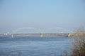 Hernando de Soto Bridge from Martyr's Park in Memphis
 Hernando de Soto Bridge illuminated at night
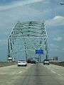 Crossing into Memphis on the Hernando de Soto Bridge
See also
-
 Bridges portal
 -
 Arkansas portal
 -
 Tennessee portal
 - List of crossings of the Lower Mississippi River
References
- ↑ Teresa R. Simpson (2008-02-17). "About.com:Memphis:The Mississippi River". About.com. Retrieved 2008-11-11.
- ↑ Chris Conley, Richard Locker (2007-08-27). "Bridge reopens after review". Commercial Appeal. Memphis, TN. Retrieved 2008-04-21.
- ↑ http://www.commercialappeal.com/news/2011/aug/14/party-to-mark-bridge-lighting/
- ↑ http://www.tdot.state.tn.us/i40hd/
External links
| Crossings of the Mississippi River | ||||
|---|---|---|---|---|
| ||||