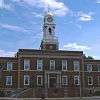
Hewlett Neck, New York
| Hewlett Neck, New York | |
|---|---|
| Village | |
| Village of Hewlett Neck | |
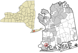 Location in Nassau County and the state of New York. | |
 Location within the state of New York | |
| Coordinates: 40°37′23″N 73°41′49″W / 40.62306°N 73.69694°WCoordinates: 40°37′23″N 73°41′49″W / 40.62306°N 73.69694°W | |
| Country | United States |
| State | New York |
| County | Nassau |
| Area | |
| • Total | 0.2 sq mi (0.6 km2) |
| • Land | 0.2 sq mi (0.6 km2) |
| • Water | 0.0 sq mi (0.0 km2) |
| Elevation | 7 ft (2 m) |
| Population (2010) | |
| • Total | 445 |
| Time zone | Eastern (EST) (UTC-5) |
| • Summer (DST) | EDT (UTC-4) |
| ZIP code | 11598 |
| Area code(s) | 516 |
| FIPS code | 36-34319 |
| GNIS feature ID | 0952663 |
Hewlett Neck is a village in Nassau County, New York in the USA. The population was 445 at the 2010 census.
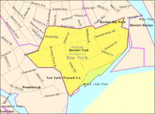
The Village of Hewlett Neck is located within the Town of Hempstead.
Hewlett Neck is included in the Five Towns, which is usually said to comprise the villages of Lawrence and Cedarhurst, as well as the hamlets of Woodmere, Inwood, and "The Hewletts," which consist of the villages of Hewlett Bay Park, Hewlett Harbor, Hewlett Neck, Hewlett, and Woodsburgh.[1]
In January 2011, Hewlett Neck was rated the No. 6 most affluent neighborhood in America by Forbes with a median household income of $239,000.[2]
Geography
Hewlett Neck is located at 40°37′23″N 73°41′49″W / 40.623170°N 73.697011°W.[3]
According to the United States Census Bureau, the village has a total area of 0.2 square miles (0.52 km2), of which, 0.2 square miles (0.52 km2) of it is land and 4.35% is water.
The community is served by the Hewlett-Woodmere School District.
Demographics
| Historical population | |||
|---|---|---|---|
| Census | Pop. | %± | |
| 1930 | 253 | — | |
| 1940 | 252 | −0.4% | |
| 1950 | 369 | 46.4% | |
| 1960 | 507 | 37.4% | |
| 1970 | 529 | 4.3% | |
| 1980 | 472 | −10.8% | |
| 1990 | 547 | 15.9% | |
| 2000 | 504 | −7.9% | |
| 2010 | 445 | −11.7% | |
| Est. 2015 | 474 | [4] | 6.5% |
As of the census[6] of 2000, there were 504 people, 155 households, and 139 families residing in the village. The population density was 2,369.1 people per square mile (926.6/km2). There were 163 housing units at an average density of 766.2 per square mile (299.7/km2). The racial makeup of the village was 98.81% White, 0.79% African American, 0.20% Asian, 0.20% from other races. Hispanic or Latino of any race were 0.99% of the population.
There were 155 households out of which 51.0% had children under the age of 18 living with them, 85.2% were married couples living together, 1.9% had a female householder with no husband present, and 10.3% were non-families. 8.4% of all households were made up of individuals and 6.5% had someone living alone who was 65 years of age or older. The average household size was 3.25 and the average family size was 3.39.
In the village the population was spread out with 33.1% under the age of 18, 5.8% from 18 to 24, 21.8% from 25 to 44, 26.0% from 45 to 64, and 13.3% who were 65 years of age or older. The median age was 39 years. For every 100 females there were 100.0 males. For every 100 females age 18 and over, there were 95.9 males.
The median income for a household in the village was $171,612, and the median income for a family was $181,530. Males had a median income of $100,000 versus $48,333 for females. The per capita income for the village was $88,049. None of the families and 1.2% of the population were living below the poverty line, including no under eighteens and 5.4% of those over 64.
References
- ↑ Barron, James. "IF YOU'RE THINKING OF LIVING IN: FIVE TOWNS", The New York Times, July 10, 1983. Accessed May 20, 2008. "The basic five are Lawrence, Cedarhurst, Woodmere, Hewlett and Inwood. But the area also includes some unincorporated communities and two tiny villages, Hewlett Bay Park and Woodsburgh, that are not added to the final total."
- ↑ Nathan Vardi (18 January 2011). "Slide Show: America's Most Affluent Neighborhoods". Forbes. Retrieved 22 February 2016.
- ↑ "US Gazetteer files: 2010, 2000, and 1990". United States Census Bureau. 2011-02-12. Retrieved 2011-04-23.
- ↑ "Annual Estimates of the Resident Population for Incorporated Places: April 1, 2010 to July 1, 2015". Retrieved July 2, 2016.
- ↑ "Census of Population and Housing". Census.gov. Retrieved June 4, 2015.
- ↑ "American FactFinder". United States Census Bureau. Retrieved 2008-01-31.