Hikurangi Plateau
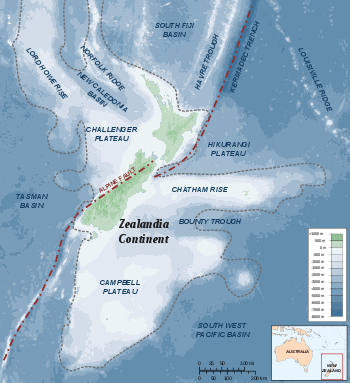
Map of Zealandia showing Hikurangi Plateau
Hikurangi Plateau is an Early Cretaceous basaltic oceanic plateau[1] in the southwestern Pacific Ocean. The portion of the plateau exposed on the seafloor has an area of 350,000 km2, and including the portions subducted beneath the North Island of New Zealand and the Chatham Rise its original area was 800,000 km2. Evidence suggests that the plateau was formed in the volcanic Greater Ontong Java Event 122 million years ago, along with the Ontong Java Plateau and the Manihiki Plateau.[2]
Hikurangi Plateau is cut by the Hikurangi Channel, a 2000 km abyssal channel that starts at Kaikoura and runs along the Hikurangi Trough as far as the Mahia Peninsula before crossing the plateau and ending in the South-west Pacific abyssal plain. [3]
References
This article is issued from Wikipedia - version of the 5/19/2015. The text is available under the Creative Commons Attribution/Share Alike but additional terms may apply for the media files.