Hinchinbrook Channel
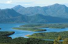
The Hinchinbrook Channel is a channel between the Australian mainland and Hinchinbrook Island. It runs for 50 km between Oyster Point, just south of Cardwell, and Lucinda in Far North Queensland. The Aboriginal name for the channel is Bolan Milbirmi. The Herbert River flows into the channel's southern point.
The Hinchinbrook Channel is protected within the Hinchinbrook Island National Park, the Great Barrier Reef Marine Park and the Great Barrier Reef World Heritage Area. Dugong feed and seek habitat in the sea grass patches along the channel seafloor. The channel is bordered by extensive, deltaic mangrove forests.[1]
The residence time of the channel is roughly 50 days.[2] This long period is due to the lack of mixing of water in creeks and mangrove forests with offshore water.
See also
References
- ↑ Daniel M., Alongi (2009). The Energetics of Mangrove Forests. Springer. p. 142. ISBN 978-1-4020-4270-6. Retrieved 11 December 2011.
- ↑ Wolanski, Eric; Yoshihiro Mazda; Keita Furukawa; Peter Ridd; Johnson Kitheka; Simon Spagnol; Thomas Stieglitz (2001). "Water Circulation in Mangroves, and its Implications for Biodivsity". In Wolanski, Eric. Oceanographic process of coral reefs: Physical and Biological Links in the Great Barrier Reef. CRC Press. p. 57. ISBN 0-8493-0833-X. Retrieved 11 December 2011.
Coordinates: 18°23′02″S 146°11′35″E / 18.384°S 146.193°E