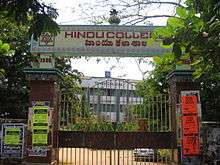
Hindu College (Guntur)
 | |
| Type | College |
|---|---|
| Established | 1930 |
| Location | Guntur City, AP, India |
| Campus | City, Suburban |
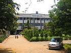
Hindu College (Guntur) was founded in 1930. It is located in Guntur City, India.
Introduction
This educational institution started its activities in 1930. The current Hindu high school started then. later it started offering other courses also. It offers graduate and under-graduate courses.[1] It has a Pharma College campus and a P.G. college on the Amaravathi Road which are recognized by the Acharya Nagarjuna University, Guntur.
History
The main city campus was established in 1930. Later the campus for the College of Pharmacy was started in the suburban area of the city. This is one of the oldest colleges in A.P. Hindu college has P.G. courses separately in Amaravathi Road which is 3 km from the main campus.
Departments
- Courses: Masters and Bachelors in Arts, Science, Mathematics, Management, Pharmaceutical.Electronics in bachelor's degree
- Separate department for National Cadet Corps) 25(A) Battalion and 2 (Armed).
- The Fine Arts department allows the student to participate in cultural activities, essay writing and drawing. The college participates in inter college competitions in Nagarjuna University and got a best college prize in 2003.
B.Sc Computer Science is the main course degree of the college.
Sister Institutions:
Hindu College of Pharmacy B.H.H. Junior college for Girls B.H.H. Degree College for women Hindu College High School Pattabhipuram High School Sri Majety Guravaiah High School Sri Majety Guravaiah Junior College Sri Majety Guravaiah Degree College
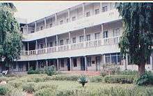
Infrastructural facilities in the College
Main Campus of about 1,15,000 Sq.Ft. built area and open land, totaling 7.5 acres(approx.) P.G. Campus of about 60,000 Sq.Ft of built up area and open land, totaling 8 acres(approx.) Vacant Land for further development, of about 20.00 acres Auditorium -Sri Aka Danadaiah Pantulu Hall Seminar Hall Agricultural Farm Andhra Bank- Campus Branch Canteen Health Center With regular O.P. facility Facility for Indoor games and Gymnasium Acharya Nagarjuna University Distance Education Centre for U.G. and P.G. Latest Communication Network like Computers, FAX, E-Mail and Internet facility. Support Services:
Central Library Computer Center Sports facility Welfare Schemes Grievance Redressal cell Vehicle placing shed etc.
References
External links
Coordinates: 16°17′48″N 80°26′33″E / 16.2966°N 80.4425°E