Historic Locust Grove
|
Locust Grove | |
|
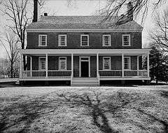
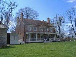
Croghan Mansion at Locust Grove | |
| Location |
561 Blankenbaker Lane Louisville, Kentucky[1] |
|---|---|
| Coordinates | 38°17′13.40″N 85°39′42.90″W / 38.2870556°N 85.6619167°WCoordinates: 38°17′13.40″N 85°39′42.90″W / 38.2870556°N 85.6619167°W |
| Built | 1790 |
| Architect | William Croghan |
| Architectural style | Georgian, Other |
| NRHP Reference # | 71000347 |
| Significant dates | |
| Added to NRHP | March 11, 1971[2] |
| Designated NHL | June 23, 1986[3] |
Historic Locust Grove is a 55-acre 18th-century farm site and National Historic Landmark situated in eastern Jefferson County, Kentucky. The site is owned by the Louisville Metro government, and operated as a historic interpretive site by Historic Locust Grove, Inc.
The main feature on the property is the ca. 1790 Georgian mansion that was the home of the Croghan family and gathering place for George Rogers Clark, Lewis and Clark, and U.S. Presidents. In addition to the mansion there is the Visitors Center that houses a gift shop, museum and meeting space.
History
The site was founded in 1790 by William Croghan and his wife Lucy Clark Croghan. Lucy was the sister of the younger William Clark of the Lewis and Clark Expedition and the older George Rogers Clark, former surveying partner of William Croghan.
On November 8, 1806, Meriwether Lewis and William Clark, tracing their way back from the Pacific Ocean, arrived at Locust Grove to a homecoming where Lucy Clark Croghan and her family welcomed them back from their journey. Locust Grove became the only residence still in existence west of the Appalachian Mountains to have sheltered Lewis and Clark. In the Fall of 2006, Locust Grove commemorated the 200th anniversary of Lewis and Clark's return.
George Rogers Clark lived at the site in the final years of his life, from 1809 to 1818.
The property was adjacent to Springfield, the home of Colonel Richard Taylor and his son, future U.S. President Zachary Taylor.[4]
Following the death of William Croghan, the estate passed to John C. Croghan, notable for his purchase of Mammoth Cave in 1838.
In the winter of 1844, the farm was the site of the efforts of African-American slave Stephen Bishop to produce a map of Mammoth Cave. The resulting map was published in 1845, and remained the most complete and accurate map of the period until modern survey techniques were applied in 1908. A significant epilogue to Bishop's story occurred in 1972, when a long-sought route connecting the caves of Flint Ridge and Mammoth Cave Ridge was discovered in an area which Bishop had mapped, but which had in the interim been almost completely flooded by the construction of a dam on the surface nearby: the area of the 20th Century connection route is shown on Bishop's 19th century map.
It was declared a National Historic Landmark in 1986.[1][3]
Gallery
 Closeup of main house
 Northeast view of main house
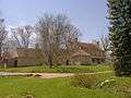 Southeast view of main house
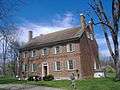 Southwest view of main house
 Log Cabin built around 1815 at the site
 The smokehouse is the only other original building at Locust Grove
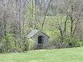 Springhouse
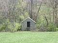 Springhouse
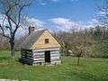 Woodworking shed
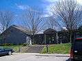 Visitor Center
See also
- Farmington Historic Plantation
- List of attractions and events in the Louisville metropolitan area
- List of parks in the Louisville metropolitan area
- Riverside, The Farnsley-Moremen Landing
References
- 1 2 Stuart K. Johnson (n.d.). "National Register of Historic Places Inventory-Nomination: Locust Grove" (pdf). National Park Service. and Accompanying 3 photos, aerial and exterior, from 1971 (32 KB)
- ↑ National Park Service (2007-01-23). "National Register Information System". National Register of Historic Places. National Park Service.
- 1 2 "Locust Grove". National Historic Landmark summary listing. National Park Service. Archived from the original on June 3, 2010. Retrieved 2008-02-23.
- ↑ Allison, Harold (1986). The Tragic Saga of the Indiana Indians. Paducah, Kentucky: Turner Publishing Company. pp. 181–182. ISBN 0-938021-07-9.
External links
| Wikimedia Commons has media related to Historic Locust Grove. |
- Official Locust Grove website
- Locust Grove—Lewis and Clark Expedition: A National Register of Historic Places Travel Itinerary
- Google Satellite Map
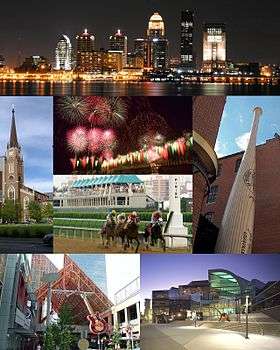
| History |
|  |
|---|---|---|
| Geography |
| |
| Government |
| |
| Transportation | ||
| Other subject areas | ||
| Top subjects | ||
| National Historic Landmarks | ||
| Prominent suburbs (over 10K pop.) | ||
| ||


| Topics | |
|---|---|
| Lists by states |
|
| Lists by insular areas | |
| Lists by associated states | |
| Other areas | |
| |