Historic regions of the United States
This is a list of historic regions of the United States.
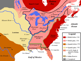
Colonial era (before 1776)

The Thirteen Colonies
- Connecticut Colony
- Delaware Colony
- Province of Georgia
- Province of Maryland
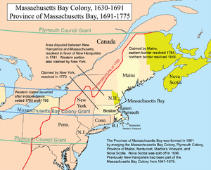
- Province of Massachusetts Bay
- Province of New Hampshire
- Province of New Jersey
- Province of New York
- Province of North Carolina
- Colony of Rhode Island and Providence Plantations
- Province of Pennsylvania
- Province of South Carolina
- Colony and Dominion of Virginia
Pre-Revolutionary War regions
{* -indicates failed legal entities}
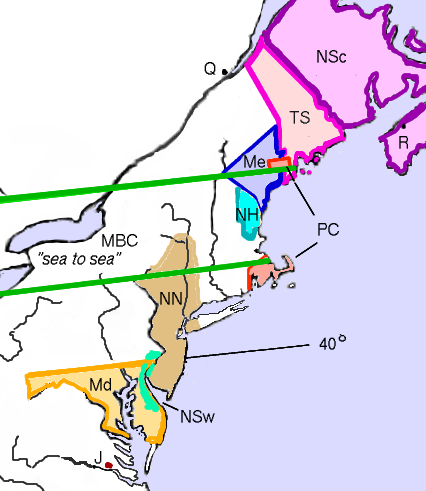
New England region
- Acadia
- Dominion of New England*
- Equivalent Lands
- King's College Tract
- Province(s) of Maine*
- Popham Colony (or Sagadahoc Colony)*
- Gorges-Mason Grant*
- Mason Lands
- Gorges Patent*
- Muscongus Patent (also known as the Waldo Patent and, eventually, the Bingham Purchase)
- Massachusetts Bay Colony
- New Hampshire Grants
- New Haven Colony
- Plymouth Colony
- Saybrook Colony
- Wessagusset Colony*
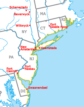
Mid-Atlantic region
Southern region
- Province of Carolina
- Fort Caroline*
- Charlesfort*
- La Florida
- San Agustín (or St. Augustine)
- San Miguel de Gualdape*
- Mocama Province*
- Jamestown
- Northern Neck Proprietary (or "Fairfax Grant")
- The Lost Colony of Roanoke*
- Stuarts Town*
Southwestern region
- Louisiana
- Louisiane
- Arkansas Post
- The German Coast; 1731
- Luisiana[1]
- Louisiane
- Tejas
- Fort Saint Louis*
- Santa Fe de Nuevo México
Interior
- District of West Augusta
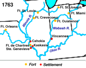
- Illinois Country
- Indiana Company
- The Indian Reserve
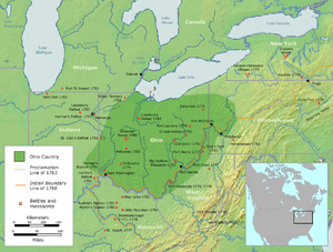
- Ohio Country (or The Ohio Company of Virginia)*
- Province of Quebec (lower portion below the Great Lakes)
Colonies settled but unrecognized
Colonies proposed but unrealized
- Charlotina Colony
- Mississippi Colony
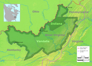
- Vandalia Colony (also called "Pittsylvania")
- Westsylvania
Independent entities later wholly admitted to the union
- Kingdom of Hawaii, later the Republic of Hawaii
- Provisional Territory of Oregon
- Republic of Texas
- Independent State of Vermont (also known as the Republic of New Connecticut)
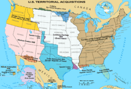
Regions purchased from foreign powers
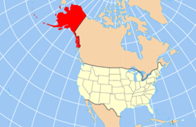
- Alaska Purchase (also called "Seward's Folly"), 1867, from Russia, for $7,200,000
- Florida Purchase (or the Spanish Cession), 1819 (effective 1821), from Spain, for $5,000,000; included:
- Gadsden Purchase, 1853, from Mexico, for $10,000,000
- Louisiana Purchase, 1803, from France, for $15,000,000.
- Virgin Islands, 1917, from Denmark, for $25,000,000
Regions annexed from or ceded by foreign powers
- American Samoa; 1899, from Germany
- The Aroostook War Compromise Lands; 1842, split jointly claimed areas with the U.K.
- Maine–New Brunswick Border
- Northwest Angle
- Rupert's Land south of the 49th parallel
- Guam; 1898, from Spain
- Mexican Cession; (effective 1848), from Mexico, including:
- Alta California (California, Nevada, Utah)
- Nuevo Mexico (New Mexico, Arizona, parts of Texas, Colorado, Oklahoma, Wyoming, Kansas)
- Northern Mariana Islands; 1945, from Japan (a U.S. administered United Nations trust territory 1945–1972; since 1972 a U.S. commonwealth)
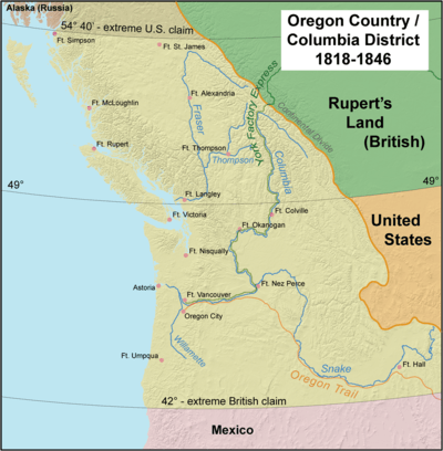
- Oregon Country (U.S.), the 1846 Oregon Treaty finally split the jointly governed region (called Columbia by the English) between the U.S. and United Kingdom at the 49th parallel.
- Pembina Region, formerly part of Rupert's Land and the Red River Colony; (often referred to as the British Cession of 1818) to U.S. in an exchange for the unorganized territory of the original Louisiana Purchase lands north of the 49th parallel.
- The Philippine Islands; 1898, from Spain; became a U.S. Territory (1900–1935) and a U.S. commonwealth (1935–1946)
- Puerto Rico; 1898, from Spain
- Texas annexation; annexed from Mexico, 1846, including most of present-day Texas and parts of Oklahoma, Colorado, Wyoming and No Man's Land; disputed with Mexico until 1848.
- included old Coahuila y Tejas areas
- Republic of West Florida Annexation; seceded from Spain, 1810; disputed with Spain until 1821.
- Baton Rouge District (annexed by the U.S., 1810)
- Mobile District (annexed by the U.S., 1812)
- United States Minor Outlying Islands (various claims)
- Some historic and current U. S. Territories
-
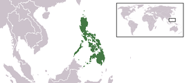
The Philippines was a commonwealth of the United States, 1935–1946
-
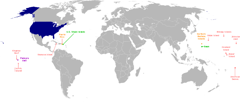
Worldwide location of current U. S. insular areas:
-
.png)
The Commonwealth of Puerto Rico
Native regions ceded to, ceded or purchased
- Black Hawk Purchase; $640,000; purchased 1832; Michigan Territory (eventually Iowa)
- Cherokee Outlet; $7,000,000; purchased 1893; Oklahoma Territory (eventually Oklahoma)
- Cherokee Strip (a disputed 2 mile wide tract of land between the Cherokee Nation and Kansas); ceded 1866; to Kansas
- The Indian Territory; ceded by the U.S. to Native Americans; 1834
- Jackson Purchase; $300,000; purchased 1818; from the Chickasaw Nation to Tennessee and Kentucky
- Platte Purchase; $7,500; purchased 1836; Missouri
- Saginaw Cession; ceded 1819; to Michigan Territory (eventually Michigan)
Interstate, territory, or the federal cessions
The following are state cessions made in the building of the U.S.
- The Delaware Wedge, dispute with Pennsylvania settled in 1921.
- Washington, D.C.; to the Federal Government from Virginia and Maryland, 1790.
- District of Columbia retrocession; the return to Virginia of the District of Columbia lands which Virginia had originally ceded for its creation, 1847.
- Greer County, Texas; a disputed county claimed both by Texas and the Federal Government; to Oklahoma Territory, 1896.
- The Honey Lands; a disputed tract of land between the Territory of Iowa and State of Missouri; to State of Iowa, 1851
- District of Kentucky; from Virginia; became the Commonwealth of Kentucky, 1792.
- Illinois County; from Virginia; became Northwest Territory, 1784.
- District of Maine; from Massachusetts; became the State of Maine, 1820.
- The Toledo Strip; the object of the nearly bloodless Toledo War between Ohio and Michigan; to Ohio, 1837.
- Washington District; from North Carolina; became the Southwest Territory, 1790.
- West Virginia; from Virginia, CSA; separating itself from the Confederacy, declared 1861; admitted to the Union in 1863.
- The Western Reserve; from Connecticut to the Northwest Territory (Ohio), 1800.
- The Yazoo Lands; from Georgia to the Mississippi Territory, 1802.
Former organized territories
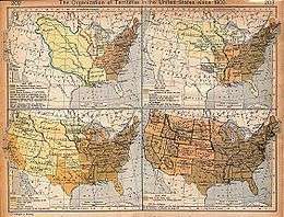
The following is a list of the 31 organized U.S. territories that have become states, in the order of the date organized.
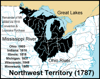
- Northwest Territory (1787–1803), became the state of Ohio, and the Territory of Indiana.
- Territory South of the River Ohio (also known as the Southwest Territory) (1790–1796) became the State of Tennessee.
- Territory of Mississippi (1798–1817) became the State of Mississippi and the Territory of Alabama.
- Territory of Indiana (1800–1816) split into the Illinois Territory, the Michigan Territory, and the State of Indiana.
- Territory of Orleans (1804–1812) became the State of Louisiana.
- Territory of Michigan (1805–1837) became State of Michigan and the Territory of Wisconsin.
- Territory of Louisiana (1805–1812) (preceded by the District of Louisiana), then renamed the Territory of Missouri.
- Territory of Illinois (1809–1818) split into the State of Illinois and additions to the Michigan Territory.
- Territory of Missouri (1812–1821) became the State of Missouri and Unorganized Territory (the eastern part of which was attached to the Territory of Michigan in 1834).
- Territory of Alabama (1817–1819) became State of Alabama.
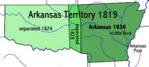
- Territory of Arkansaw (1819–1836) became the State of Arkansas, additions to the unorganized territory of the original Louisiana Purchase, and the unorganized Indian Territory (which eventually spawned Indian Territory, Oklahoma Territory and No Man's Land).
- Territory of Florida (1822–1845) became the State of Florida.
- Territory of Wisconsin (1836–1848) split into the State of Wisconsin, the Iowa Territory and Unorganized Territory.
- Territory of Iowa (1838–1846) split into the State of Iowa and unorganized territory of the original Louisiana Purchase.
- Territory of Oregon (1848–1859) preceded by the unrecognized Oregon Country; split into the State of Oregon and Washington Territory.
- Territory of Minnesota (1849–1858) preceded (mostly) by unorganized territory of the original Louisiana Purchase; split into the State of Minnesota and unorganized territory of the original Louisiana Purchase.
- Territory of New Mexico (1850–1912) preceded by Nuevo Mexico; (the southern part was known as the Arizona Territory (CSA) (1861–1864) by the Confederate States of America); split into the Arizona Territory (USA) and State of New Mexico (USA).
- Territory of Utah (1850–1896) preceded by Alta California and the unrecognized State of Deseret; split into the State of Utah, the Nevada Territory, additions to the Colorado Territory and additions to the Wyoming Territory.
- Territory of Washington (1853–1889) became the State of Washington and additions to the Idaho Territory.
- Territory of Kansas (1854–1861) preceded by unorganized territory of the original Louisiana Purchase; split into the State of Kansas and additions to the Colorado Territory.
- Territory of Nebraska (1854–1867) preceded by unorganized territory of the original Louisiana Purchase; split into the State of Nebraska, the Dakota Territory, additions to the Idaho Territory and additions to the Colorado Territory.
- Territory of Colorado (1861–1876) preceded by parts of the territories of: Kansas, Utah, New Mexico and Nebraska; became the State of Colorado. (See also Jefferson Territory.)
- Territory of Nevada (1861–1864) preceded by the Utah Territory and the unrecognized State of Deseret; became the State of Nevada.
- Territory of Dakota (1861–1889) became the State of North Dakota, the State of South Dakota, additions to the Idaho Territory and additions to the Wyoming Territory.
- Territory of Arizona (1863–1912) became the State of Arizona and an addition to the State of Nevada.
- Territory of Idaho (1863–1890) preceded by parts of the territories of: Washington, Dakota, and Nebraska; became the State of Idaho, the Montana Territory, additions to the Dakota Territory and additions to the Wyoming Territory.
- Territory of Montana (1864–1889) became the State of Montana.
- Territory of Wyoming (1868–1890) preceded by parts of the territories of: Dakota, Utah and Idaho; became the State of Wyoming.
- Territory of Oklahoma (1890–1907) (preceded by the unorganized Indian Territory (1834–1907) and the Neutral Strip; became the State of Oklahoma.
- Territory of Hawaii (1898–1959) preceded by the Republic of Hawaii; became the State of Hawaii.
- Territory of Alaska (1912–1959) (preceded by the Department of Alaska and the District of Alaska); became the State of Alaska.
Internal land of the United States
- Internal United States land grants, cessions, districts, departments, claims and settlements
The following are land grants, cessions, defined districts (official or otherwise) or named settlements made within an area that was already part of a state of the Union or U.S. territory that did not involve international treaties or Native American cessions or land purchases.
- Cumberland District, North Carolina (also called the District of Miro); Tennessee.
- District of Louisiana; Missouri, Kansas, Iowa, Nebraska, Minnesota, North and South Dakota, Montana, Arkansas, Oklahoma, Colorado, Wyoming; renamed Missouri Territory in 1812.
- Military Tract of 1812; Illinois, Michigan, Arkansas, Missouri.
- Ohio Country; parts of Ohio, Indiana, Pennsylvania, West Virginia.
Alaska
- District of Alaska; renamed the Alaska Territory in 1912.
Colorado
- Pike's Peak Country; Colorado.
Iowa
Nebraska
New York

- Central New York Military Tract (New York)
- The Holland Purchase (New York)
- Macomb's Purchase (New York)
- Mill Yard Tract (New York)
- The Morris Reserve (New York)
- Phelps and Gorham Purchase (New York)
- The Triangle Tract (New York)
Ohio
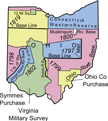
- Canal Lands
- College Lands
- College Township
- Congress Lands (or Congressional Lands, 1798–1821)
- Dohrman Tract
- Ephraim Kimberly Grant
- Firelands or Sufferers' Lands
- French Grant
- Indian Land Grants
- Maumee Road Lands
- Michigan meridian (or Michigan Meridian Survey; also Toledo Tract)
- Miami & Erie Canal Lands
- Ministerial Lands
- Moravian Indian Grants
- Ohio & Erie Canal Lands
- The Ohio Company
- Donation Tract
- First Purchase
- Purchase on the Muskingum (or Second Purchase)
- Refugee Tract
- Salt Reservations (or Salt Lands)
- School Lands
- Seven Ranges (or Old Seven Ranges)
- Symmes Purchase (or Miami Purchase; also the Land Between the Miamis)
- Turnpike Lands
- Twelve Mile Square Reservation
- Two Mile Square Reservation
- United States Military District
- Virginia Military District
- Zane's Tracts (or Zane's Grant; also Ebenezer Zane Tract)
Oklahoma
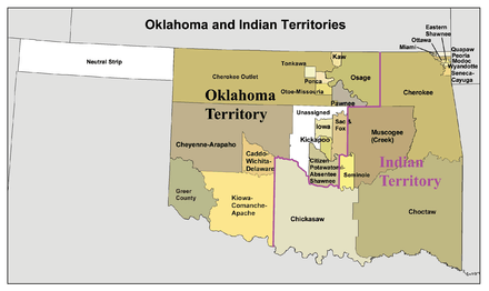
- Big Pasture
- Indian Territory or The Oklahoma Indian Country
- Neutral Strip (or No Man's Land)
- Unassigned Lands
Indian Reserves
- The original and current Cherokee Nation
- Cheyenne-Arapaho Reserve
- Comanche, Kiowa and Apache Reserve
- Iowa Reserve
- Kaw Reserve
- Kickapoo Reserve
- Osage Reserve
- Ponca and Otoe–Missouria Reserve
- Citizen Potawatomi and Absentee Shawnee Reserve
- Sac and Fox Reserve
- Tonkawa Reserve
- Wichita and Caddo Reserve
Pennsylvania

U.S. mainland military districts/departments
These entities were sometimes the only governmental authority in the listed areas, although they often co-existed with civil governments in scarcely populated states and territories. Civilian administered "military" tracts, districts, departments, etc., will be listed elsewhere.
Central United States
- Department of the Northwest (1862–1865) Dakota, Minnesota, Montana, Wisconsin, Iowa, Nebraska[2]
- District of Minnesota (1862–1865)
- District of Wisconsin (1862–1865)
- District of Iowa (1862–1865)
- District of Dakota (1862–1866)
- District of Montana (1864–1866)
- Department of the Missouri (1861–1865) Missouri, Arkansas, Illinois, part of Kentucky, and later Kansas; re-configured in 1865 as part of the Division of the Missouri.
- Division of the Missouri (1865–1891).
- Department of Dakota (1866–1911) Minnesota, Montana, North Dakota, and parts of Idaho, South Dakota and the Yellowstone portion of Wyoming.
- Department of the Missouri (1865–1891) Arkansas, Kansas, Missouri, Indian Territory, and Territory of Oklahoma.
- Department of the Platte (1866–1898) Iowa, Nebraska, Colorado, Dakota Territory, Utah Territory, Wyoming (except Yellowstone), and a portion of Idaho.
- Department of Texas (1871–1880) (originally part of the Department of the Gulf) Texas after 1865.
- Department of New Mexico (1854–65) New Mexico Territory; previously part of the District of California and the Department of the West.
Pacific area
- Pacific Division (1848–1853) lands won in the Mexican–American War; became the original Department of the Pacific in 1853.
- Military Department 10 (1848–1851) California.
- Military Department 11 (1848–1851) Oregon Territory.
- Department of the Pacific (1853–1858; and 1861–1865); separated into the Department of California and the Department of Oregon in 1858.
- District of Oregon (1853–1858) Washington Territory, Oregon Territory.
- District of California (1853–1858) California, New Mexico Territory; Utah added 1858
During the Civil War the Department of the Pacific had six subordinate military districts:
- District of Oregon (headquarters at Fort Vancouver) January 15, 1861 – July 27, 1865
- District of California (headquarters at San Francisco, co-located with Department of the Pacific). Independent command from Department from (July 1, 1864 – July 27, 1865); those parts of California not in other districts.
- District of Southern California (September 25, 1861 – July 27, 1865); Counties of Southern California (southward from San Luis Obispo and Tulare Counties).
- District of Humboldt (December 12, 1861 – July 27, 1865); Del Norte, Humboldt, Klamath, Mendocino Counties of California.
- District of Utah (August 6, 1862 – July 27, 1865); Utah Territory, Nevada Territory, later State of Nevada.
- District of Arizona (March 7, 1865 – July 27, 1865); Territory of Arizona
The Department of California (1858–1861) comprised the southern part of the Department of the Pacific: California, Nevada, and southern part of Oregon Territory; merged into the Department of the Pacific as the District of California.
The Department of Oregon (1858–1861) comprised the northern part of the Department of the Pacific: Washington Territory and Oregon Territory.
- Military Division of the Pacific (1865–1891).
- Department of Alaska (1868–1884) became the civilian-ruled District of Alaska.
- Department of Arizona (1865–1891) Arizona Territory; included New Mexico Territory after 1885.
- Department of the Columbia (1865–1891) Oregon, Washington Territory, part of Idaho Territory, and Alaska after 1870.
- District of Oregon (1865–1867) Washington Territory, Oregon Territory and Idaho Territory.
- New Department of California (1865–1891) California, Nevada Territory, Arizona Territory, and part of New Mexico Territory.
The south

- Department of the Gulf (1862–1865; created by the U.S. for the Civil War) Mississippi, Alabama, Louisiana, and Texas.
- Trans-Mississippi (or Trans-Mississippi Department; CSA) (1862–1865) Formerly "Military Dept. 2"; Missouri, Arkansas, Texas, Indian Territory (now Oklahoma), Kansas, and Louisiana west of the Mississippi River.
The west
- Department of the West (1853–1861) all U.S. lands between the Mississippi River and the Military District of the Pacific not included in other Districts or Departments.
Retroceded possessions and overseas territories
- Chamizal, Texas, to Mexico.
- The Milk River and Poplar River cessions to the United Kingdom, in the Treaty of 1818.
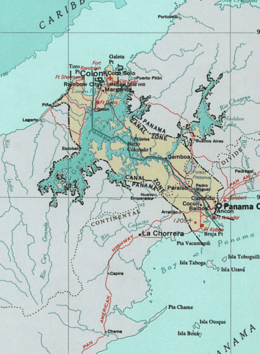
- Panama Canal Zone, to Panama.
- Commonwealth of the Philippines to Republic of the Philippines.
- Rio Rico, Texas (Horcón Tract) to Mexico.
U.S. military overseas regions
- United States Military Government in Cuba (1898–1902)
- United States Military Government in Guam (1898–1950)
- United States Military Government of the Philippine Islands (1898-1902)
- United States Military Government in Puerto Rico (1898–1900)
- United States Military Government in Cuba (1906-1909)
- United States Occupation of Veracruz, Mexico (1914)
- American WWII European Occupation Zones
- American Occupation Zone of Austria (1945–1955)
- American Occupation Zone of Germany (1945–1949)
- American Occupation Zone of West Berlin (1945–1990)
- Free Territory of Trieste, Zone A (1947–1954, administered jointly with the U.K.)
- American Occupation of Japan (1945–52)
- American Occupation of South Korea (1945–1948)
- Pacific Trust Territories; included the Republic of Palau and the Marshall Islands (Micronesia under U.S. administration, 1947–1986)
- Ryukyu Islands, Japan (Okinawa, 1945–1972)
- Coalition Provisional Authority, Iraq (2003-2004)
Functioning but non-sanctioned territories
These "territories" had actual, functioning governments (recognized or not):
- Cimarron Territory
- State of Deseret
- State of Frankland / Franklin 1784
- Jefferson Territory
- Long Republic
- Nataqua Territory
- Trans-Oconee Republic
Civil War-related
Functioning governments created as a result of the attempted secession of the Confederacy. Some were enclaves within opposing territories:
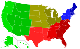
- Confederate States of America – CSA –see map.
- Arizona Territory (CSA) (parts of the territories of Arizona and New Mexico)
- State of Dade
- Free and Independent State of Scott (see Scott County, Tennessee)
- Second Republic of South Carolina
These were regions disassociated from neighboring areas due to opposing views:
- Nickajack
- Republic of Winston (see Winston County, Alabama)
- State of Scott, seceded from Tennessee, becoming a Union enclave.
Non-extant entities
Proclaimed
These entities have been proclaimed (or have existed de facto) in the past, but have never had an elected, recognized, or functioning government:
- Absaroka
- Kingdom of Beaver Island
- Republic of California (also known as the "Bear Flag Republic") (June 14, 1846 – July 9, 1846); then becoming the unorganized "Territory of California".
- Conch Republic
- Republic of Kinney
- Republic of Madawaska
- McDonald Territory
- Sovereign State of Muskogee
- Republic of the Rio Grande
- Great Republic of Rough and Ready
- State of Westmoreland (also see Westmoreland County, Connecticut)
- Sovereign State of Winneconne
- Some Flags of Historic U. S. Regions
-

The unrecognized Sovereign State of Muskogee declared by William Bowles in 1799
-
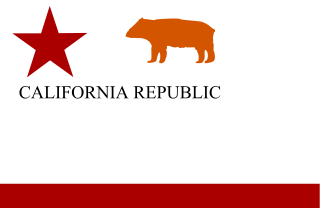
The original Bear Flag only flew over California for 25 days, unrecognized by any country
-
Contemporary U.S. flag raised 23 June 1846 by Army Major John C. Frémont claiming California as a territory of the United States, replacing the short-lived Bear Flag Banner
-
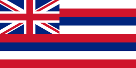
Flag of the Kingdom of Hawai'i, 1894-1898.
-

Flag of the U.S. Territory of the Panama Canal Zone, flown 1903–1979
Proposed

These are state or territorial proposals actually brought to either a congressional, legislative or popular vote; but which never became a functioning entity:
- State of Delmarva or, "Eastern Shore"; 1998
- The State of Shasta (1852); State of Klamath (1853); followed by the State of Jefferson (1854) for virtually the same Pacific northwest areas
- State of Jefferson
- Proposed State of Jefferson (Rocky Mountains), 1859, was an attempt to legitimize the Jefferson Territory, stalled by the Civil War; failed proposal.
- Proposed State of Jefferson (Texas), 1870 and 1915 statehood proposals both died in committee.
- Territory of Colorado (California) 1860, stalled in Congress by the Civil War; a proposal to form a territory from Southern California following a successful popular referendum.
- State of Kanawha a proposed name for the state that became West Virginia, 1861
- State of Lincoln
- Northwestern State of Lincoln, several proposals after 1865
- Southern State of Lincoln, 1869
- State of Sequoyah, 1905
- State of West New York, several proposals brought into the New York Legislature since the 1990s, all of which have been defeated
Proposals never voted on
These are failed state or territorial proposals whose establishment proposals never were voted on, or never made it out of committee:
- Cascadia
- State of Superior (or Ontonagon), 1858
Native American-related proposed regions
- Aztlán (a future reincarnation of a defunct, mythical Aztec Empire to be "re"-established in lands now found in the Southwestern U.S., a central theme in Chicano political activism.)
- Comancheria, area inhabited and intermittently controlled by the Comanche and their allies.
- Dinétah, the claimed original Navajo homeland
- Republic of Lakotah, the proposed Sioux upper Midwestern mega-state.
- Lenapehoking, would be named for the Delaware or Lenilenape Indians.
Regional nicknames
Belts
Belts are loosely defined sub-regions found throughout the United States:
- Bible Belt
- Black Belt
- Borscht Belt
- Frontier Strip
- Frost Belt
- Grain Belt or Corn Belt
- Mormon Corridor or "Jello Belt"
- Lead Belt
- Rust Belt
- Snow Belt
- Sun Belt
- Tornado Alley
See also
- European colonization of the Americas
- List of former United States counties
- List of regions of the United States
- Political divisions of the United States
- Territories of the United States on stamps
References
- ↑ "Luisiana". Artifacts.org. Retrieved 2012-09-17.
- ↑ Heidler, David Stephen; Heidler, Jeanne T.; Coles, David J.; Encyclopedia of the American Civil War: A Political, Social, and Military History; W. W. Norton & Company; New York; 2000; p. 590.
External links
| Wikimedia Commons has media related to Historical regions of the United States. |
- Official Name and Status History of the several States and U.S. Territories
- Indian Land Cessions in the United States, 1784–1894; United States Serial Set, Number 4015
- United States Territorial Maps 1775–1920
- Spanish Luisiana
| Demographics | |
|---|---|
| Economy | |
| Environment | |
| Geography | |
| Government | |
| Health | |
| History | |
| Law | |
| Miscellaneous | |
| |