History of Kent
Kent is a county in South East England with a long history of human occupation.
Prehistoric Kent

Kent has been occupied since the Lower Palaeolithic as finds from the quarries at Swanscombe attest. The Swanscombe skull, uncovered at Barnfield Pit, a quarry in Swanscombe, is the oldest skull found in Britain. Identified as Homo heidelbergensis it dates to the Hoxnian Interglacial 400,000 years ago.[1]
During the Neolithic the Medway megaliths were built and there is a rich sequence of Bronze Age occupation indicated by finds and features such as the Ringlemere gold cup.
Iron Age Kent
The name Kent probably means 'rim' or 'border' (compare the dictionary words cant in English, Kant in German, etc.), regarding the eastern part of the modern county as a 'border land' or 'coastal district.' Historical linguists believe that the proto-Indo-European root *kanthos could not pass into a Germanic language with its initial K sound intact, so the word must have passed via an intermediate language, either Celtic or Latin. Julius Caesar described it as Cantium, although he did not record the inhabitants' name for themselves, in 51 BC. His writings suggest localised groups of people whose chieftains were flattered by his description of them as 'kings'. Writing of the Britons generally in his Commentarii de Bello Gallico Caesar noted that: "...by far the most civilised are those who inhabit Cantium, the whole of which is a maritime region; and their manners differ little from those of the Gauls". Pottery studies indicate the county east of the River Medway was inhabited by Belgic peoples who were part of an economic and cultural region embracing south east England and the lands across the English Channel.
The extreme west of the modern county was occupied by other Iron Age tribes; the Regnenses and possibly another ethnic group occupying The Weald known today as the Wealden People. During the late pre-Roman Iron Age the names of a few Welsh kings are known, such as Dumnovellaunus and Adminius.
Roman Kent
.jpg)
Although now two miles from the sea amid the marshes of east Kent, Richborough Castle was arguably the Romans' main entry point when they invaded Britain in circa AD 43. They established a bridgehead and commemorated their success by building a triumphal arch whose cross shaped foundations still survive at the site which is now looked after by English Heritage.
Roman Britain was under attack by Saxon and other raiders in the 3rd Century and it became necessary to fortify the once-prosperous commercial port of Rutupiae. Triple ditches and ramparts were dug (still visible round the site of the arch Richborough Castle although the defences were completely revamped after a decade or so and Richborough was provided with its circuit of towered stone walls and outer ditches, becoming one of the most important of the Saxon shore forts. It was one of the last to be regularly occupied and there is evidence of a large Roman population here in the early 5th century, some of them worshipping in the Early Christian church discovered in a corner of the fort.
Early Medieval Kent
East Kent became one of the kingdoms of the Jutes during the 5th century AD (see Kingdom of Kent) and the area was later known as Cantia in around 730 and Cent in 835. The early Medieval inhabitants of the county were known as the Cantwara or Kent people, whose capital (the only town called a metropolis by Bede [2]) was at Canterbury.
Canterbury is the religious centre of the Anglican faith, and see of Saint Augustine of Canterbury. Augustine is traditionally credited with bringing Christianity to Anglo Saxon England, landing at Ebbsfleet, Pegwell Bay on the Isle of Thanet (northeast of Kent) in the spring of 597.
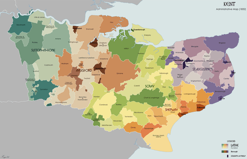
A lathe was an ancient administration division of Kent, and may well have originated during a Jutish colonisation of the county. These ancient divisions still exist, but have no administrative significance today. There were seven Lathes in Kent at the time of the Domesday Book, which reveals that in 1086 Kent was divided into the seven lathes or "lest(um)": Aylesford, Milton, Sutton, Borough, Eastry, Lympne and Wye. For administrative, judicial and taxation purposes these units remained important for another 600 years, although by 1295 the number of lathes had reduced to five: Borough and Eastry were merged to form the Lathe of St. Augustine, the lathe of Lympne was renamed the Lathe of Shepway, the lathes of Milton and Wye were merged to form the Lathe of Scray.[3][4] Each of the lathes were divided into smaller areas called hundreds, although the difference between the functions of lathes and hundreds remains unclear.[5]
Medieval Kent
Following the invasion of Britain by William of Normandy the people of Kent adopted the motto Invicta meaning undefeated and claiming that they had frightened the Normans away, as they merely used Kent to reach London. Once London was reached, the Normans ignored most of East Kent, due to the peasants attacking them at every turn. As a result, Kent became a semi-autonomous County Palatine under William's half-brother Odo of Bayeux, with the special powers otherwise reserved for counties bordering Wales and Scotland.[6] A decade after the Norman conquest, Penenden Heath near Maidstone was the scene of a successful trial of Odo of Bayeux. The trial, ordered by William I at the behest of Lanfranc, Archbishop of Canterbury challenged the Earl's purported landholdings in the county, an event which represented an important attempt by Saxon landowners to reassert their pre-Norman rights and privileges.[7]
Gavelkind was one of the most interesting examples of customary law in England. After the Norman Conquest, gavelkind was superseded by the feudal law of primogeniture, except in South East England. In essence, the law meant that on death, a man's property was equally divided amongst his surviving sons, which led to land being divided into ever smaller parcels. Therefore, the wasteful strip system of farming in open fields was never established in Kent. Gavelkind was finally abolished by the Law of Property Act in 1925.[8]
During the medieval period, Kent produced several rebellions including the Peasants' Revolt led by Wat Tyler and later, Jack Cade's rebellion of 1450. Thomas Wyatt led an army into London from Kent in 1553, against Mary I. Canterbury became a great pilgrimage site following the martyrdom of Thomas Becket,[9] who was eventually canonised in 1246.[10] Canterbury's religious role also gave rise to Chaucer's Canterbury Tales, a key development in the rise of the written English language and ostensibly set in the countryside of Kent. Rochester had its own martyr, William of Perth, and in 1256 Lawrence, Bishop of Rochester travelled to Rome to obtain William's canonisation.[10]
As well as numerous fortified manor houses, Kent has a number of traditional militarily significant castles, including those at Allington, Chilham, Dover, Hever, Leeds, Rochester and Walmer, built to protect the coast, the River Medway or routes into London.
Kent also played a significant role in the English Civil War around 1648.[11]
Early Modern Kent
The Royal Navy first used the River Medway in 1547 when a storehouse was rented on 'Jyllingham Water'. By the reign of Elizabeth I (1558–1603) a small dockyard had been established at Chatham. By 1618, storehouses, a ropewalk, a drydock and houses for officials had been built downstream from Chatham.[12]
By the 17th century, tensions between Britain and the continental powers of the Netherlands and France led to increasing military build-up in the county. Forts were built all along the coast following a daring raid by the Dutch navy on the shipyards of the Medway towns in 1667.[13]
The 18th century was dominated with wars with France, and the Medway became the prime position to base a fleet that would act against the Dutch and French Coasts. When the theatre of operation moved to the Atlantic, Portsmouth and Plymouth assumed these roles and Chatham concentrated on shipbuilding and ship repair. Many of the Georgian naval buildings are still extant. In peacetime the work force at Chatham Dockyard was reduced to a quarter of its wartime roll.[12]
Chatham Dockyard built over 400 naval ships including HMS Victory in the age of ships of the line, ironclads including HMS Africa 1905, and 57 submarines, while also refitting ships. The keel for HMS Victory was laid at Chatham on 23 July 1759.[14] During World War II, Chatham refitted 1360 warships such as HMS Ajax.[12] Charles Dickens' father worked in the dockyard, and Chatham, Rochester and the Cliffe marshes were to feature in many of his books.[15]
As an indication of the area's military importance, the first Ordnance Survey map ever drawn was the 1 inch map of Kent, published in 1801. Work on the map started in 1795.[16]
In the early 19th century smugglers were very active on the Kent coastline, with gangs, such as the Aldington Gang bringing spirits, tobacco and salt to Kent, taking goods like wool across the English Channel to France.[17]
On Saturday night, 28 August 1830, a widespread uprising by rural workers began in East Kent, with the destruction of threshing machines in the Elham Valley area and by the third week of October, over one hundred machines had been destroyed.[18] The uprising, that eventually became known as the Swing Riots, spread across southern England and East Anglia.[18] The general unrest, particularly about the state of the workhouses, was instrumental in the introduction of the Poor Law Amendment Act 1834.[18]
Kent and London
Historically, much of what is now the south-east quadrant of London was a suburban and rural part of Kent. However, since the 19th century this urban region has been detached administratively from remaining more rural county.
When the County of London was created by the Local Government Act 1888, the new county incorporated part of north west Kent including Deptford, Greenwich, Woolwich and Lewisham. Penge was gained from Surrey by the London Government Act 1899.
The London Government Act 1963 created an enlarged Greater London in 1965 which took in more of northwest Kent. The Local Government Act 1972 abolished the previous structure of local government in 1974 and created a new non-metropolitan county of Kent, divided into districts. It also abolished Canterbury as a county borough which became a district under the new county council. The places that had been removed in 1888 were amalgamated to form the London Borough of Lewisham and the Royal Borough of Greenwich and two further boroughs were created. These were the London Borough of Bromley, an amalgamation of Bromley, Beckenham, Chislehurst, Orpington and Penge and the London Borough of Bexley comprising Bexley, Sidcup, Erith and Crayford.
Modern Kent
Much of the Battle of Britain during World War II was fought in the skies over the county, and between June 1944 and March 1945, over 10,000 V1 flying bombs, or Doodlebugs were fired on London from bases in Northern France. Many were destroyed by aircraft, anti-aircraft guns or barrage balloons, but around 2500 fell on the capital - but almost the same number fell in Kent, and the area became known as Doodlebug Alley.[19]
Much of the north-west of the county is part of the London commuter belt. The Thames Gateway regeneration area includes riverside areas of north Kent as far east as Sittingbourne and largely to the north of the A2 road. Much of Kent, especially the Medway area, saw post-war migration from London. This was partly because of the heavy damage and destruction sustained by London in World War II.
In 1998, Rochester, Chatham, Gillingham and Rainham left the administrative county of Kent to form the Unitary Authority of Medway, but remain in the ceremonial county of Kent.[20]
The two cities in Kent were Canterbury, the seat of the Archbishop of Canterbury, and Rochester, the seat of the Bishop of Rochester. However, since 1998 when local government was reorganised, Rochester lost its official city status through an administrative oversight; attempts are now being made to regain it.[21]
Man of Kent or Kentish Man?
Kent is traditionally divided into West Kent and East Kent by the River Medway. This division into east and west is a reflected in the term "Men of Kent" for residents east of the Medway; those from west are known as "Kentish Men". The female equivalents are "Maid of Kent" and "Kentish Maid".[22] These one-time traditional subdivisions of the English county of Kent, are kept alive today by the Association of the Men of Kent and Kentish Men: an organisation formed in 1913. The Association website can be found here.
However, further investigation shows that the division is not the Medway, but further east in Gillingham. Edward Hasted, in his 1798 description of Rainham, writes: "The whole of this parish is in the division of East Kent which begins here, the adjoining parish of Gillingham, westward, being wholly in that of West Kent."
The division, according to one historian, Freddie Cooper, a former Mayor of Gillingham, remained until 1 April 1929 when Rainham was transferred, despite protest, from the administration of Milton Rural District Council to that of Gillingham.
Most English counties have nicknames for people from that county, such as a Tyke from Yorkshire and a Yellowbelly from Lincolnshire; the traditional nickname for people from Kent is "Kentish Long-Tail", deriving from the long-held belief on the continental mainland of Medieval Europe that the English had tails.[23]
See also
- Category:History of Kent
- 1989 Deal barracks bombing
- History of Folkestone
References
- ↑ Palmer, Lyn. "Kent's Greatest Archaeological Discoveries". Exploring Kent's Past. Kent County Council. Retrieved 16 September 2015.
- ↑ Hindley, Geoffrey. A Brief History of The Anglo-Saxons. 2007.
- ↑ J. E. A. Jolliffe, "The Hidation of Kent", in English Historical Review, Vol. 44, No. 176 (Oct., 1929), pp. 612-618
- ↑ 1611 map of the Lathes of Kent accessed 6 March 2008
- ↑ Jessup, Frank W. History of Kent. 1958
- ↑ David Bates (1975). The Character and Career of Odo, Bishop of Bayeux (1049/50-1097). Speculum.
- ↑ W Levison (October 1912). A Report on the Penenden Trial. The English Historical Review.
- ↑ Jessup, Frank W. (1966). Kent History Illustrated. Kent County Council.
- ↑ "Pilgrimage to Canterbury". Spartacus.schoolnet.co.uk. Retrieved 2007-04-20.
- 1 2 Barnard, Derek. Merrily to Frendsbury — A History of the Parish of Frindsbury. City of Rochester Society. Retrieved 2007-04-20.
- ↑ "1648: Kent & Essex". British-Civil-Wars.co.uk. Retrieved 2007-04-19.
- 1 2 3 The Historic Dockyard Chatham — where legends were created. Jarrold Publishing. 2005.
- ↑ "The Dutch In The Medway". DeRuyter.org. Retrieved 2007-04-20.
- ↑ "Service Career". The Official HMS Victory Website. Retrieved 2007-04-19.
- ↑ "Charles Dickens". InfoBritain. Retrieved 2007-04-20.
- ↑ Oliver, Richard (1995). Ordnance Survey maps: a concise guide for historians 2nd Ed. Ordnance Survey. ISBN 1-870598-24-5.
- ↑ "South-East England". Smuggler's Britain. Retrieved 2007-04-20.
- 1 2 3 Harrison, L F C (1989). The Common People, a History from the Norman Conquest to the Present. Glasgow: Fontana. pp. 249–253. ISBN 0-0068-6163-6.
- ↑ "WW2 People's War". BBC.co.uk. Retrieved 2007-04-19.
- ↑ "Medway". Communities and Local Government. Retrieved 2007-04-20.
- ↑ "Error costs Rochester city status". BBC News. 2002-05-16. Retrieved 2007-04-20.
- ↑ Rayner, Stephen (October 2004). "Men of Kent: Sorry ... but we're joining a new tribe". Medway News.
- ↑ Layamon (1205). Brut.
Further reading
- Edward Wedlake Brayley (1808), Beauties of England and Wales, 7, London: Vernor, Hood, and Sharpe (includes Kent)
- Kent. Journey-Book of England. London: Charles Knight & Co. 1842.
External links
- Edward Hasted's 'History and Topographical Survey of Kent': full-text version of some of the volumes of the standard parish history of the county (second edition).
- Anglo-Saxon Kent Electronic Database (ASKED)
.svg.png)
Kent Portal | |
| Unitary authorities | |
| Boroughs or districts | |
| Major settlements |
|
| Rivers | See: Rivers of Kent |
| Topics | |