Hochsimmer
| Hochsimmer | |
|---|---|
|
The Hochsimmer with Sankt Johann (left) and Ettringen (right) | |
| Highest point | |
| Elevation | 587.9 m above sea level (NHN) (1,929 ft) [1] |
| Coordinates | 50°21′38″N 7°11′55″E / 50.360694°N 7.198556°ECoordinates: 50°21′38″N 7°11′55″E / 50.360694°N 7.198556°E |
| Geography | |
 Hochsimmer | |
| State/Province | DE-RP |
| Parent range | Eifel (Eastern High Eifel) |
| Geology | |
| Mountain type |
Basalt Cinder cone |
.JPG)
The Hochsimmer is a volcanic cone, 587.9 m above sea level (NHN),[1] in the Eifel Mountains in Germany. It rises near Ettringen in the Rhineland-Palatine county of Mayen-Koblenz. At the summit is an observation tower, the Hochsimmer Tower.
Geography
Location
The Hochsimmer rises within the High Eifel (East Eifel) around 1.7 km west-northwest of the village of Ettringen. Flowing past its western foot roughly from north to south is part of the middle reaches of the Rhine tributary, the Nette. Through its valley runs the Landesstraße 83, which links Weibern to the northwest with Mayen to the southeast. At the eastern foot of the hill is the L 82 road to Bell, and, at its southern foot is the village of St. Johann.
Height and summits
The Hochsimmer has two domed summits or kuppen: the West Top (West Top 50°21′38.5″N 7°11′54.8″E / 50.360694°N 7.198556°E) is 587.9 m high and the East Top (East Top 50°21′36.3″N 7°12′9.1″E / 50.360083°N 7.202528°E) is 583.3 m high. About 600 metres southwest of the summit is the Kleiner Simmer (514.7 m).[1]
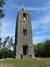
Towers
On the east top of the Hochsimmer stands the 18-metre-high Hochsimmer Tower, an observation tower built in 1909 and 1911. From its viewing platform there is a view of the Eastern High Eifel, the Middle Rhine Basin and of Ettringen; in good visibility, even Cologne Cathedral may be seen. About 30 metres northwest of the viewing tower is a transmission tower.
Gallery
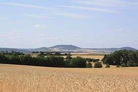
 The Hochsimmer from the south
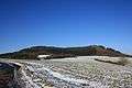
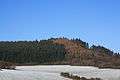 The East Top from the south
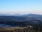 The Hochsimmer (right), seen from the Hohe Acht
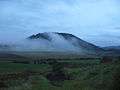 View from Hochstein
References
- 1 2 3 Map service of the Landscape Information System of the Rhineland-Palatinate Nature Conservation Office (Naturschutzverwaltung Rheinland-Pfalz)
See also
External links
| Wikimedia Commons has media related to Hochsimmer. |
- Der Hochsimmer…, retrieved 28 November 2013, in Gemeinde Ettringen am Hochsimmer, at ettringen-eifel.de.