Horseshoe Bend (Arizona)
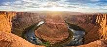
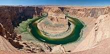
Horseshoe Bend is a horseshoe-shaped meander of the Colorado River located near the town of Page, Arizona, in the United States.
Horseshoe Bend is located 5 miles (8.0 km) downstream from the Glen Canyon Dam and Lake Powell within Glen Canyon National Recreation Area, about 4 miles (6.4 km) southwest of Page.
It is accessible via hiking a 1.5-mile (2.4 km) round trip from U.S. Route 89, but an access road also reaches the geological structure, as it is part of a state park. Horseshoe Bend can be viewed from the steep cliff above.[1]
The overlook is 4,200 feet (1,300 m) above sea level, and the Colorado River is at 3,200 feet (980 m) above sea level, making it a 1,000-foot (300 m) drop.[2]
The rock walls of Horseshoe Bend contain a variety of minerals, among which are hematite, platinum and garnet.
References
- ↑ "Horseshoe Bend Hiking Guide" (PDF). National Park Service. October 2007. Retrieved November 26, 2014.
- ↑ "Google terrain maps".
External links
| Wikimedia Commons has media related to Horseshoe Bend (Arizona). |
Coordinates: 36°52′46″N 111°30′50″W / 36.87944°N 111.51389°W