Hosanger
| Hosanger kommune | |
|---|---|
| Former Municipality | |
|
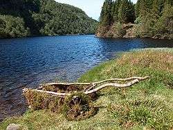
View of the lake Kossdalsvatnet | |
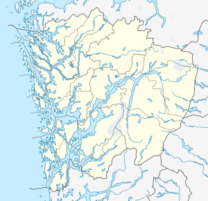 Hosanger kommune Location in Hordaland county | |
| Coordinates: 60°34′30″N 05°28′39″E / 60.57500°N 5.47750°ECoordinates: 60°34′30″N 05°28′39″E / 60.57500°N 5.47750°E | |
| Country | Norway |
| Region | Western Norway |
| County | Hordaland |
| District | Nordhordland |
| Municipality ID | NO-1253 |
| Adm. Center | Hosanger |
| Area[1] | |
| • Total | 228 km2 (88 sq mi) |
| Population (1964) | |
| • Total | 2,442 |
| Time zone | CET (UTC+01:00) |
| • Summer (DST) | CEST (UTC+02:00) |
| Created as | Formannskapsdistrikt in 1838 |
| Merged into | Osterøy in 1964 |
Hosanger is a former municipality in Hordaland county, Norway. The municipality existed from 1838 until its dissolution in 1964. The municipality originally covered all the lands on both sides of the Osterfjorden-Romarheimsfjorden from the Lonevågen fjord all the way east to the county border at the end of the Modalen valley. Hosanger also included an exclave on the Lindås peninsula surrounding the village of Seim at the southern end of the Lurefjorden. Seim was separated from the rest of Hosanger by part of Lindås municipality. Over time the areas of Seim and Modalen were split off from Hosanger. The administrative centre of the municipality was the village of Hosanger, where Hosanger Church is located.[1]
History
The parish of Hosanger was established as a municipality on 1 January 1838 (see formannskapsdistrikt). On 1 January 1885, the exclave of Seim was separated from Hosanger and merged into the new municipality of Alversund. This left Hosanger with 3,387 residents. On 1 January 1867, the Øksendalen farm (population: 28) in the Eksingedalen valley was transferred from the municipality of Voss to Hosanger by Royal resolution. On 1 January 1910, the eastern part of Hosanger (population: 821) which included the Modalen and Eksingedalen valleys was separated from Hosanger to form the new municipality of Modalen. The split left Hosanger with 2,524 inhabitants. On 1 January 1964, the municipality of Hosanger was dissolved and its lands were divided as follows amongst its neighbors:
- All of Hosanger located north of the Osterfjorden (population: 791) became a part of the enlarged Lindås municipality
- All of Hosanger located on the island of Osterøy (population: 1,616) became a part of the new municipality of Osterøy.[2]
Hosanger Church

The historic Hosanger Church (Hosanger kyrkje) was built in 1796. It is located in the village of Hosanger and it served as the main church for the municipality. It is a Romanesque-style church constructed of brick and stone. On the site there once was a stave church dating back to the Middle Ages. It was first mentioned in historical records in 1329. Later, a wooden church was constructed. The wooden church was struck by lightning and burned down on Christmas Day 1795. From 1863 until 1865, the church was extended to the west. The vestry extension on the south side of the church was built in 1962-1964.[3][4]
Notable residents
- Nicolai Wergeland, (1780-1848), priest and politician that wrote the Norwegian Constitution of May 1814
- Arne Bjørndal (1882-1965), hardingfele fiddler, composer, and folklorist
- Nils Andresson Lavik (1884-1966), politician from the Christian Democratic Party of Norway
- Johannes Lavik (1856-1929), journalist and newspaper editor
References
- 1 2 Store norske leksikon. "Hosanger" (in Norwegian). Retrieved 2014-04-23.
- ↑ Jukvam, Dag (1999). "Historisk oversikt over endringer i kommune- og fylkesinndelingen" (PDF) (in Norwegian). Statistisk sentralbyrå.
- ↑ Hosanger kyrkje (Den Norski Kirke)
- ↑ Hosanger kyrkjelyd (Den norske kirke - Kirkerådet)