Hubbard Park Historic District
|
Hubbard Park Historic District | |
 | |
  | |
| Location | Hubbard Park, Mercer Circle and Sparks Sts., Cambridge, Massachusetts |
|---|---|
| Coordinates | 42°22′36″N 71°7′54″W / 42.37667°N 71.13167°WCoordinates: 42°22′36″N 71°7′54″W / 42.37667°N 71.13167°W |
| Area | 6.8 acres (2.8 ha) |
| Built | 1885 |
| Architect | Multiple |
| Architectural style | Colonial Revival, Tudor Revival, Queen Anne |
| MPS | Cambridge MRA |
| NRHP Reference # | 82001950[1] |
| Added to NRHP | April 13, 1982 |
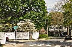
The Hubbard Park Historic District encompasses a residential development and park west of Harvard Square in Cambridge, Massachusetts. The area was originally the estate of Gardiner Hubbard, who had a 6-acre (2.4 ha) estate and house on nearby Brattle Street. In the 1880s Hubbard commissioned architects to build a ring of high quality homes around his mansion, which was demolished in 1939 and is now the site of Hubbard Park. The houses in this development are now located on Mercer Circle, Sparks Street, and Hubbard Park Road.[2]
The district was listed on the National Register of Historic Places (NRHP) in 1982.[1]
See also
- Hubbard Park in Meriden, Connecticut, also listed on the NRHP
- National Register of Historic Places listings in Cambridge, Massachusetts
References
- 1 2 National Park Service (2009-03-13). "National Register Information System". National Register of Historic Places. National Park Service.
- ↑ "MACRIS inventory record for Hubbard Park Historic District". Commonwealth of Massachusetts. Retrieved 2014-03-19.
| Topics |  | ||||||||||||||||||||||||||||||
|---|---|---|---|---|---|---|---|---|---|---|---|---|---|---|---|---|---|---|---|---|---|---|---|---|---|---|---|---|---|---|---|
| Lists by county | |||||||||||||||||||||||||||||||
| Lists by city |
| ||||||||||||||||||||||||||||||
| Other lists | |||||||||||||||||||||||||||||||
| |||||||||||||||||||||||||||||||
This article is issued from Wikipedia - version of the 11/26/2016. The text is available under the Creative Commons Attribution/Share Alike but additional terms may apply for the media files.