Hunga Tonga
| Hunga Tonga | |
|---|---|
|
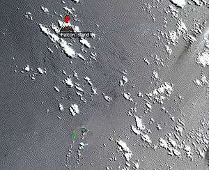
NASA satellite image of Falcon Island (in red), showing Hunga Tonga-Hunga Haʻapai (in green) | |
| Height | 149 metres (489 ft) |
| Location | |
| Coordinates | 20°34′S 175°23′W / 20.57°S 175.38°W |
| Country | Tonga |
| Geology | |
| Type | Submarine volcano |
| Last eruption | December 2014 to January 2015 |
Hunga Tonga-Hunga Haʻapai is a volcano located about 30 kilometres (19 miles) south-southeast of Fonuafoʻou (also known as Falcon Island),[1] an island which is part of the nation of Tonga.
The volcano is part of the highly active Tonga-Kermadec Islands volcanic arc, a subduction zone extending from New Zealand north-northeast to Fiji.[2][3] The volcano lies about 100 kilometres (62 mi) above a very active seismic zone.[3][4] Magma is formed as two tectonic plates melt together under high heat and pressure, and the superheated rock is forced to the surface. The island arc is formed at the convergent boundary where the Pacific Plate subducts under the Indo-Australian Plate.[4][5]
Volcano and caldera
The volcano itself is a submarine volcano[6] lying underwater between the two islands, which are the remnants of the western and northern rim of the volcano's caldera.[1] The two islands (part of the Haʻapai group)[7] are about 1.6 kilometres (0.99 mi) apart,[8] and each is about 2 km (1.2 mi) long and composed largely of andesite.[3][4] Hunga Tonga reaches an elevation of 149 metres (489 ft), while Hunga Haʻapai comes to only 128 metres (420 ft) above sea level.[1] Neither island is large: Hunga Tonga is roughly 390,000 square metres (0.15 sq mi) and Hunga Haʻapai is 650,000 square metres (0.25 sq mi) in size.[9] Neither island is developed due to a lack of an acceptable anchorage, although there are large guano deposits on each island.[7][10]
Submarine eruptions at a rocky shoal - about 3.2 kilometres (2.0 mi) southeast of Hunga Haʻapai and 3 kilometres (1.9 mi) south of Hunga Tonga - were reported in 1912 and 1937.[1] Another eruption occurred from a fissure 1 kilometre (0.62 mi) south-southeast of Hunga Haʻapai in 1988.[1]
The islands figure in Tongan mythology as one of the few islands which were not overfished, and hence thrown down from heaven to land on earth.[11][12] Tongans called them the islands which "jump back and forth" (i.e. suffer earthquakes).[11] The first Europeans to see the islands were those with the Dutch explorers Willem Schouten and Jacob Le Maire in 1616, although the British explorer Captain James Cook visited them several times in 1777 and learned their Tongan names.[13]
2009 eruption
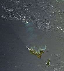
On March 16, 2009, a submarine eruption near Hunga Tonga-Hunga Haʻapai began spewing steam, smoke, pumice, and ash thousands of feet into the sky above the ocean.[14][15] By March 21, Tonga's chief geologist, Kelepi Mafi, reported lava and ash issuing from two vents—one on the uninhabited island Hunga Haʻapai and another about 100 metres (330 ft) offshore. The eruption had filled the gap between the two vents, creating new land surface that measured hundreds of square metres.[16][17] The eruption devastated Hunga Haʻapai, covering it in black ash and stripping it of vegetation and fauna.[17]
The volcanic eruption drew worldwide attention. The volcano was featured in a segment of the television program Angry Planet in 2009.[18]
2014–15 eruption
In November and December 2014, volcanic activity at volcanoes and a series of earthquakes occurred north of Tonga for several weeks, indicating renewed volcanic activity in the area.[19]
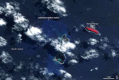
A new eruption began at Hunga Tonga-Hunga Haʻapai on December 19, 2014. Local fishermen reported a tall white steam plume rising from the ocean over the undersea volcanic mount. Satellite images taken on December 29 showed the eruption continuing, with a smoke and ash plume rising from the site, and discolored seawater (possibly caused by smoke and ash released below the surface, or by disturbance of the seabed).[20] The eruption continued into 2015, with a tall ash cloud rising 3 kilometres (9,800 ft) into the sky on January 6, 2015.[21]
The eruption entered a new stage on January 11, 2015, when the volcano began sending ash plumes as high as 9 kilometres (30,000 ft) into the sky. An Air New Zealand flight on January 12 had to be diverted to Samoa, while a number of other flights between New Zealand and Tonga were cancelled.[22] An ash plume reached 4.5 kilometres (15,000 ft) on January 13, and the large amounts of nitrogen and phosphorus released underwater caused an explosion in the growth of algae and causing a red tide.[19] Officials identified two vents, one on Hunga Haʻapai and another about 100 metres (330 ft) offshore and underwater.[23] Large rocks and wet, dense ash were being ejected up to 400 metres (1,300 ft) into the air.[23][24] By January 16, a new island had been formed by the explosion.[25] Tongan officials estimated the new island to be 1 kilometre (0.62 mi) wide, 2 kilometres (1.2 mi) long, and 100 metres (330 ft) high,[23][24] although geologists said the new island would probably exist only a few months until ocean waves wore it down.[26] Ash and acid rain were falling in an area about 10 kilometres (6.2 mi) from the new island, and Hunga Tonga and Hunga Haʻapai had both been denuded of vegetation.[23][24]
Despite the volcano's ongoing eruption, which was spewing a steam cloud 1 kilometre (0.62 mi) into the air,[24] international flights to Tonga resumed on January 16, as volcano and aviation experts deemed the eruption no longer a threat to airliners.[23]
Geologists from Tonga and New Zealand who visited the volcano on January 19 said the eruption had quieted in the last 24 hours. They noted that nearly all the eruption was now coming from the vent on the new island, with steam clouds rising to a height of 7 to 10 kilometres (4.3 to 6.2 mi), and ash and rock being thrown to a height of about 200 to 300 metres (660 to 980 ft). Emission of ash was limited, with magma rocks hitting the ocean causing some steam explosions. The team found no floating volcanic debris, such as pumice rafts, and the smell of volcanic gases was intermittent. Tongan officials established a zone 20 kilometres (12 mi) in diameter around the island to protect visitors from rock, ash, and acid rain.[27]
Tongan officials declared the eruption at an end on January 26,[28] after observing no new gas, ash, or rock emerging from the island vent.[29] By this time, the island was 1 to 2 kilometres (0.62 to 1.24 mi) wide, 2 kilometres (1.2 mi) long, and 120 metres (390 ft) high.[28][29] The island had joined with Hunga Haʻapai, and was about 200 metres (660 ft) away from joining with Hunga Tonga.[28][29] Locals visiting the island said seabirds were nesting.[30]
See also
References
- 1 2 3 4 5 "Hunga Tonga-Hunga Ha'apai". Global Volcanism Program. Smithsonian Institution.
- ↑ Clift, Peter D.; Rose, Estelle F.; Shimizu, Nobumichi; Layne, Graham D.; Draut, Amy E.; and Regelous, Marcel. "Tracing the Evolving Flux From the Subducting Plate in the Tonga-Kermadec Arc System Using Boron in Volcanic Glass." Geochimica et Cosmochimica Acta. 65:19 (October 2001).
- 1 2 3 Gupta, Alok K. Igneous Rocks. Mumbai, India: Allied Publishers, 1998. ISBN 81-7023-784-X
- 1 2 3 Ewart, A.; Bryan, W.B.; and Gill, J.B. "Mineralogy and Geochemistry of the Younger Volcanic Islands of Tonga, S.W. Pacific." Journal of Petrology. 14:3 (1973).
- ↑ Ewart, A. "A Petrological Study of the Younger Tongan Andesites and Dacites, and the Olivine Tholeiites of Niua Fo'ou Island, S. W. Pacific." Contributions to Mineralogy and Petrology. 58:1 (January 1976); Hawkesworth, C.J.; Turner, S.P.; McDermott, F.; Peate, D.W.; and van Calsteren, P. "U-Th Isotopes in Arc Magmas: Implications for Element Transfer from the Subducted Crust." Science. 276:5312 (April 25, 1997).
- ↑ Arnberger, Erik. The Tropical Islands of the Indian and Pacific Oceans. Vienna: Austrian Academy of Sciences Press, 2001. ISBN 3-7001-2738-3
- 1 2 Wells, Susan M.; Sheppard, Charles; and Jenkins, Martin. Coral Reefs of the World: Central and Western Pacific. United Nations Environment Programme, 1988. ISBN 2-88032-945-0
- ↑ Pacific Islands Pilot. London: Great Britain Hydrographic Department, 1969.
- ↑ Dahl, Arthur L. Review of the Protected Areas System in Oceania. IUCN Commission on National Parks and Protected Areas. United Nations Environment Programme, 1986. ISBN 2-88032-509-9
- ↑ Fletcher, Matt and Keller, Nancy J. Tonga. Oakland, Calif.: Lonely Planet, 2001. ISBN 1-74059-061-9; Bulletin - Department of Minerals and Energy, Bureau of Mineral Resources, Geology and Geophysics. Australia Bureau of Mineral Resources, Geology and Geophysics, 1964.
- 1 2 Gifford, Edward Winslow. Tongan Myths and Tales. London: The British Museum, 1924.
- ↑ Nunn, Patrick D. "Fished Up or Thrown Down: The Geography of Pacific Island Origin Myths." Annals of the Association of American Geographers. 93:2 (November 2004).
- ↑ Suren, Peter. Essays on the History of the Discovery and Exploration of Tonga by the Europeans. Nukuʼalofa, Kingdom of Tonga: Friendly Islands Bookshop, 2001; Rutherford, Noel. Friendly Islands: A History of Tonga. Cambridge: Oxford University Press, 1977. ISBN 0-19-550519-0; Cook, James. The Journals of Captain Cook. John Cawte Beaglehole and Philip Edwards. New York: Penguin Classics, 1999. ISBN 0-14-043647-2
- ↑ "Tongan Inspectors Head to Undersea Volcano." Associated Press. March 19, 2009.
- ↑ The date the eruption began is uncertain. According to the Smithsonian Institution's Global Volcanism program, "Observers flying near the area of Hunga Tonga-Hunga Ha'apai (about 62 km NNW of Nuku'alofa, the capital of Tonga) on 16 or 17 March reported seeing an eruption." See: SI/USGS Weekly Volcanic Activity Report. 11 March-17 March 2009. The report cites Keizo Gates' Web log, dated March 16, 2009, which contains photos allegedly taken from civilian aircraft late on the afternoon of March 16. See: Gates, Keizo. "New Tonga Eruption" Kzo.net. March 16, 2009. The Smithsonian subsequently confirmed that the eruption began on March 16. See: SI/USGS Weekly Volcanic Activity Report. 18 March-24 March 2009.
- ↑ Percival, Jenny. "Underwater Volcano Creates New Island Off Tonga." The Guardian. 21 March 2009.
- 1 2 "'No Living Thing Left' As Tonga Volcano Erupts." Agence France Presse. March 20, 2009.
- ↑ "Entertainment," Cape Argus, November 20, 2009.
- 1 2 Woollaston, Victoria (January 13, 2015). "Fire in the South Pacific: Hunga Ha'apai underwater volcano erupts to turn the sea blood red and the sky grey with ash". Daily Mail. Retrieved January 13, 2015.
- ↑ Klemetti, Erik (December 30, 2014). "New Eruption at Hunga Tonga-Hunga Ha'apai". Wired. Retrieved January 9, 2015; "Undersea eruption from Hunga Tonga-Hunga Ha'apai in Tonga, South Pacific Ocean". MODIS Web. NASA. January 9, 2015. Retrieved January 9, 2015.
- ↑ "Hunga Tonga-Hunga Ha'apai". Global Volcanism Program, National Museum of Natural History, Smithsonian Institution. January 7, 2015. Retrieved January 9, 2015.
- ↑ Tapaleao, Vaimoana (January 13, 2015). "Tongan volcano eruption puts flights on alert". New Zealand Herald. Retrieved January 12, 2015.
- 1 2 3 4 5 "Tongan volcano creates new island: Officials". The Star. January 16, 2015. Retrieved January 16, 2015.
- 1 2 3 4 "Photos: Massive ash cloud in Tonga volcano eruption". TV New Zealand. January 16, 2015. Retrieved January 16, 2015.
- ↑ "Tongan volcano forms new island". Radio Australia. January 16, 2015. Retrieved January 16, 2015.
- ↑ Perry, Nick (21 January 2015). "New island created by underwater volcanic eruption in Tonga may soon disappear". The Independent. Retrieved 21 January 2015.
- ↑ "Geo survey reports less ash coming from volcano". Matangi Tonga. January 19, 2015. Retrieved January 19, 2015.
- 1 2 3 "Volcanic eruption ends, leaving tiny ash island". Matangi Tonga. January 26, 2015. Retrieved January 26, 2015.
- 1 2 3 "Volcano eruption in Tonga declared over". Radio New Zealand. January 26, 2015. Retrieved January 26, 2015.
- ↑ Pearlman, Jonathan (March 11, 2015). "First photographs emerge of new Pacific island off Tonga". Daily Telegraph. Retrieved March 12, 2015.
External links
- "Underwater Volcano Erupts Off Tonga." BBC News. March 19, 2009. - Video showing the March 18, 2009, eruption
- "Expedition To A New Island" - Explorer George Kourounis sets foot on a brand new volcanic island