Huntsville Commercial Historic District
|
Huntsville Commercial Historic District | |
 | |
  | |
| Location | Roughly bounded by War Eagle, Hughes, Church, and Harris St., Huntsville, Arkansas |
|---|---|
| Coordinates | 36°5′22″N 93°44′8″W / 36.08944°N 93.73556°WCoordinates: 36°5′22″N 93°44′8″W / 36.08944°N 93.73556°W |
| Area | 7.3 acres (3.0 ha) |
| Built | 1939 |
| Architectural style | Early Commercial, Art Deco |
| NRHP Reference # | 08000705[1] |
| Added to NRHP | July 24, 2008 |
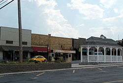
The Huntsville Commercial Historic District encompasses the historic elements of the business district of Huntsville, Arkansas, the county seat of Madison County. It covers an area three blocks by two, extending east-west between Hughes and Harris Streets, and north-south between War Eagle and Church Streets. Most of the buildings in the district were built after fires swept through the town in 1902 and 1925, although the Madison County Courthouse is an Art Deco structure built in 1939. The district includes 32 historically significant buildings.[2]
The district was listed on the National Register of Historic Places in 2008.[1]
See also
References
- 1 2 National Park Service (2010-07-09). "National Register Information System". National Register of Historic Places. National Park Service.
- ↑ "NRHP nomination for Huntsville Commercial Historic District" (PDF). Arkansas Preservation. Retrieved 2015-09-11.
| Topics | |
|---|---|
| Lists by states |
|
| Lists by insular areas | |
| Lists by associated states | |
| Other areas | |
| |
This article is issued from Wikipedia - version of the 12/2/2016. The text is available under the Creative Commons Attribution/Share Alike but additional terms may apply for the media files.