Hurricane Anna (1961)
| Category 3 major hurricane (SSHWS/NWS) | |
 Anna near peak intensity on July 21 | |
| Formed | July 20, 1961 |
|---|---|
| Dissipated | July 24, 1961 |
| Highest winds |
1-minute sustained: 115 mph (185 km/h) |
| Lowest pressure | 976 mbar (hPa); 28.82 inHg |
| Fatalities | 1 direct |
| Damage | $300,000 (1961 USD) |
| Areas affected | Windward Islands, Trinidad and Tobago, Venezuela, Leeward Antilles, Colombia, Jamaica, Nicaragua, Honduras, Belize, Guatemala, Mexico |
| Part of the 1961 Atlantic hurricane season | |
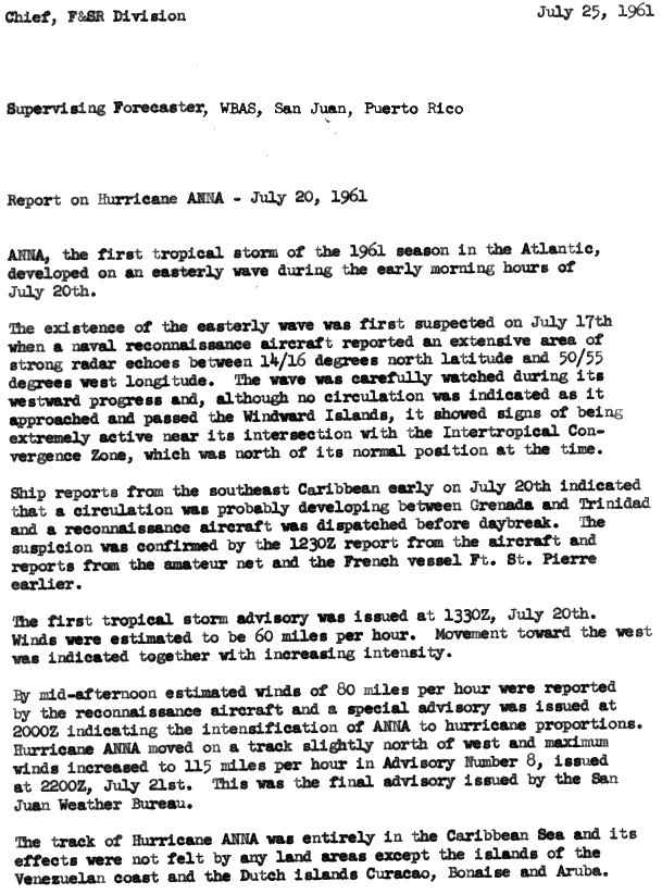
Hurricane Anna impacted Central America and the Windward Islands in July 1961. The first tropical cyclone and first hurricane of the hurricane season, Anna developed on July 20 from an easterly wave located in the Intertropical Convergence Zone (ITCZ) over the Windward Islands. Initially a tropical storm, it moved westward across the Caribbean Sea. Favorable environmental conditions allowed Anna to reach hurricane intensity late on July 20. Early on the following day, the storm strengthened into a Category 2 hurricane on the modern-day Saffir–Simpson hurricane wind scale. Intensification continued, and later on July 21, Anna became a major hurricane,[nb 1] upon reaching Category 3 intensity. After attaining peak intensity on July 22, the hurricane slightly weakened while brushing the northern coast of Honduras. Further weakening occurred; when Anna made landfall in landfall in Belize (then known as British Honduras) on July 24, winds decreased to 80 mph (130 km/h). Anna rapidly weakened over land and dissipated later that day.
As a developing tropical cyclone over the Leeward Islands, Anna produced strong winds over Grenada, though damage was limited to some crops, trees, and telephone poles. Other islands experienced gusty winds, but no damage. Passing just north of Venezuela, the hurricane produced strong winds over the country, peaking as high as 70 mph (115 km/h). Strong winds caused widespread damage in northern Honduras. Throughout the country, at least 36 homes were destroyed and 228 were damaged. Severe damage in the Gracias a Dios Department left hundreds of people homeless. Additionally, high winds toppled approximately 5,000 coconut trees. Overall, Anna caused a fatality and $300,000 in damage (1961 USD),[nb 2] primarily in Central America.
Meteorological history

The origins of Hurricane Anna were likely from an easterly wave located over Africa. On July 16, Television Infrared Observation Satellite (TIROS) imagery showed a cloud mass situated about 1,020 miles (1,640 km) west-southwest of the southernmost islands of Cape Verde.[2] The existence of an easterly wave was not confirmed by United States Navy reconnaissance aircraft and ship reports until the following day, at which time the system was located over 445 miles (715 km) east of Antigua. Although no circulation existed while the wave approached the Windward Islands, significant amounts of deep convection was associated with the system and located near the Intertropical Convergence Zone (ITCZ). Early on July 20, ship reports indicated a developing circulation between Grenada and Trinidad;[3] squalls on the former island produced wind gusts as strong as 50 mph (80 km/h).[4] According to HURDAT – the North Atlantic hurricane database – the system developed into Tropical Storm Anna at 0000 UTC on July 20,[5] as confirmed by a reconnaissance aircraft flight.[4]
Situated about 25 miles (40 km) east-northeast of Tobago with an initial wind speed of 40 mph (65 km/h),[5] Anna immediately began to strengthen while moving slightly north of due west. The first advisory on Anna, issued at 1330 UTC on July 20, reported sustained winds of 60 mph (95 km/h). Later that day, the storm was upgraded to a hurricane after a reconnaissance aircraft reported hurricane-force winds.[3] Anna then deepened more steadily, becoming a Category 2 hurricane early on July 21. Later that day, the storm became a major hurricane by 1800 UTC, after reaching Category 3 hurricane intensity. At 1200 UTC on July 22, Anna attained its peak intensity with maximum sustained winds of 115 mph (185 km/h) and a minimum barometric pressure of 976 mbar (28.8 inHg). Early on July 23, Anna weakened to a Category 2 hurricane while beginning to brush the northern coast of Honduras. Weakening continued, and by early on July 24, the storm deteriorated to a Category 1 hurricane. Around 1200 UTC, Anna made landfall in a rural area of Stann Creek District, Belize with winds of 80 mph (130 km/h). Late on July 24, the system weakened to a tropical storm and then dissipated.[5]
Preparations
The United States Weather Bureau issued tropical cyclone watches and warnings for Venezuela, Curaçao, Bonaire and Aruba.[6] In Jamaica, meteorologists forecast that the storm would bypass the island to the south without causing any effects.[7] As Anna continued westward, it was predicted to make landfall in either northern Nicaragua or southeastern Honduras. Residents in those countries were advised to take precautions ahead of the storm.[8][9] Central Americans residing along Gulf of Honduras were also warned about 10 feet (3.0 m) tides and strong winds.[10] As the storm neared Honduras, small boats and other water craft were advised to remain in port.[11] Additionally, a hurricane watch was posted for the Swan Islands.[12] In Belize, the threat of the storm forced 100 residents to evacuate their homes, while numerous businesses were closed down. At Belize Harbor, many ships and boats were moved upstream inland.[13] The hurricane was also forecast to bring heavy rainfall to the mountainous areas of Belize, causing a concern for flash flooding.[14] Additionally, Belize's Church Welfare Service began to ship clothing and other materials in anticipation of the hurricane.[13]
Impact
.jpg)
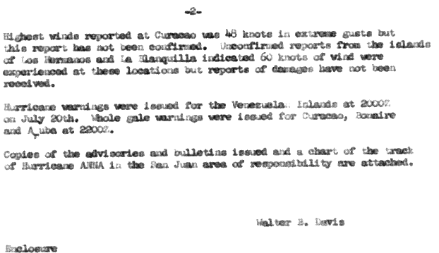
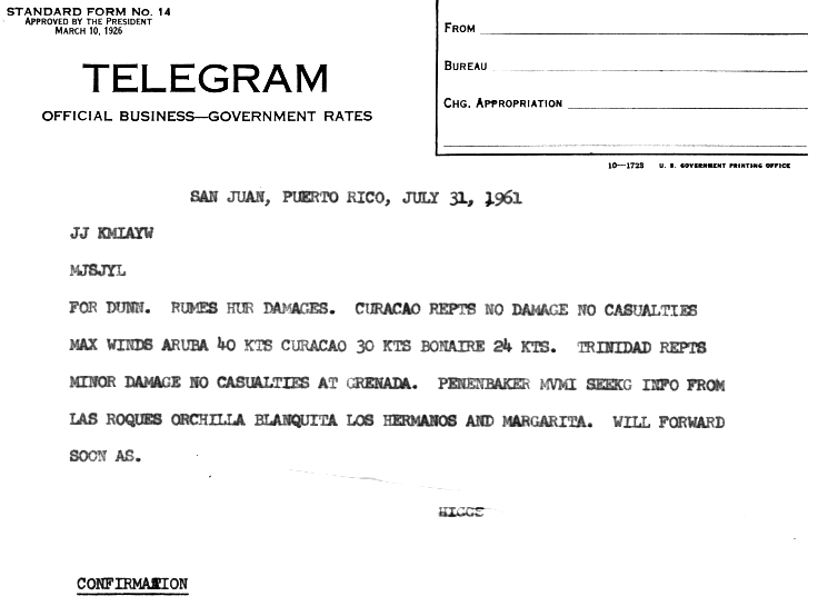
In Grenada, Anna produced wind gusts of 50 mph (80 km/h).[4] Damage from the storm's impact on Grenada was limited to banana crops, trees, and telephone poles.[7] Winds were light on Barbados and Saint Lucia, reaching only 29 mph (47 km/h) on both islands.[2] Damage on Trinidad was minor.[15] In northern Venezuela and the ABC Islands, the storm produced winds of 50–70 mph (80–113 km/h) in Curaçao, Los Hermanos and La Blanquilla;[6] A weather station in Aruba reported winds of 50 mph (80 km/h).[15]
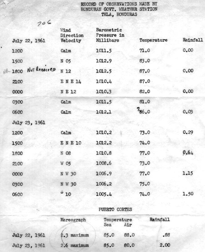
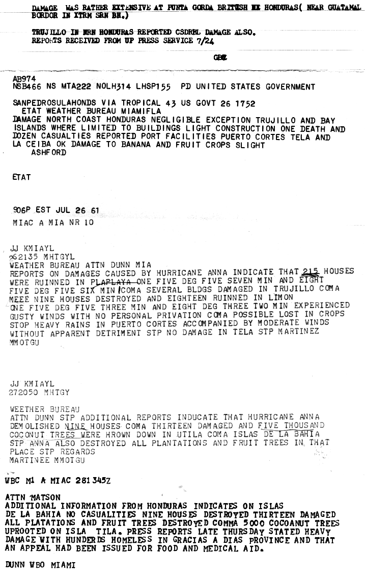
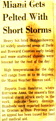
In Honduras, damage from Anna was moderate and limited to the Atlantic coast. A weather station in Tela recorded rainfall of 0.29–1.5 inches (7.3–25.4 mm) over a two-day period, and another station in Puerto Cortés measured 2 inches (51 mm).[16] In Plaplaya, the storm damaged 215 homes. In Trujillo, a number of buildings suffered damage.[17] At Limón, nine houses were destroyed and eighteen more were left uninhabitable.[17] Serious damage also occurred in Gracias a Dios Department, where hundreds of people were left homeless.[18] On the Bay Islands, nine houses were demolished and thirteen suffered damage. High winds toppled about 5,000 coconut trees on Útila.[17] Damage from Anna in Honduras amounted to $300,000.[4] The hurricane killed one person and injured 12 others, and victims required food and medical aid in Anna's wake.[18] In Belize, Anna produced waves 7–10 ft (2.1–3 m) and gusty winds.[14] Though unspecific, there were reports of considerable damage in the country.[4]
See also
Notes
- ↑ A major hurricane is a storm that ranks as Category 3 or higher on the Saffir–Simpson Hurricane Scale.[1]
- ↑ All damage figures are in 1961 United States dollar, unless otherwise noted
References
- ↑ Landsea, Chris (June 1, 2015). "What is a super-typhoon? What is a major hurricane? What is an intense hurricane?". In Goldenberg, Stan. Frequently Asked Questions (FAQ) (4.8 ed.). Miami, Florida: Atlantic Oceanographic and Meteorological Laboratory. Retrieved December 3, 2013.
- 1 2 Fritz, Sigmund (December 1962). "Satellite Pictures And The Origin Of Hurricane Anna" (PDF). Monthly Weather Review. Washington, D.C.: American Meteorological Society, PDF document hosted by National Oceanic and Atmospheric Administration. 90: 507–513. Bibcode:1962MWRv...90..507F. doi:10.1175/1520-0493(1962)090<0507:SPATOO>2.0.CO;2. Retrieved December 2, 2013.
- 1 2 Higgs, Ralph L. (August 4, 1961). Report on Hurricane Anna – July 20, 1961 (Report). San Juan, Puerto Rico: San Juan Weather Bureau Office, as archived by the National Hurricane Center. p. 1. Retrieved December 2, 2013.
- 1 2 3 4 5 Dunn, Gordon E. (March 1962). The Hurricane Season of 1961 (PDF). Monthly Weather Review (Report). 90. Miami, Florida: American Meteorological Society, PDF document hosted by National Oceanic and Atmospheric Administration. pp. 108, 110. doi:10.1175/1520-0493(1962)090<0107:THSO>2.0.CO;2. Retrieved December 2, 2013.
- 1 2 3 National Hurricane Center; Hurricane Research Division (July 6, 2016). "Atlantic hurricane best track (HURDAT version 2)". United States National Oceanic and Atmospheric Administration. Retrieved December 8, 2016.
- 1 2 Ralph L. Higgs (August 4, 1961). Report on Hurricane Anna - July 20, 1961. U.S. Weather Bureau Office San Juan, Puerto Rico (Report). San Juan, Puerto Rico: National Oceanic and Atmospheric Administration; National Hurricane Center. p. 2. Retrieved December 2, 2013.
- 1 2 "Anna Should Miss Jamaica". The Daily Gleaner. 1961.
- ↑ "Hurricane's Sight Set on North Coast of Nicaragua". The Daily Courier. United Press International. 1961.
- ↑ "Hurricane Roars Across Caribbean". Arizona Daily Sun. Associated Press. 1961.
- ↑ "Anna Bites At British Honduras". The Miami News. July 23, 1961. Retrieved December 2, 2013.
- ↑ "Hurricanes Path Leading to Honduras". Sunday Gazette-Mail. United Press International. 1961.
- ↑ "Hurricane Aims At Honduras; Warnings Out". The Palm Beach Post. Miami, Florida. United Press International. July 23, 1961. Retrieved December 2, 2013.
- 1 2 "Anna British Honduras Bound last night". The Daily Gleaner. 1961.
- 1 2 "Hurricane Anna hits Honduras". Great Bend Daily Tribune. Associated Press. 1961.
- 1 2 Ralph L. Higgs (August 4, 1961). Report on Hurricane Anna - July 20, 1961. U.S. Weather Bureau Office San Juan, Puerto Rico (Report). San Juan, Puerto Rico: National Oceanic and Atmospheric Administration; National Hurricane Center. p. 11. Retrieved December 3, 2013.
- ↑ Record Of Observations Made By Honduran Govt. Weather Station Tela, Honduras. Tela Railroad Co. (Report). San Juan, Puerto Rico: National Oceanic and Atmospheric Administration; National Hurricane Center. July 27, 1961. p. 2. Retrieved December 3, 2013.
- 1 2 3 Etat; Gordon E. Dunn (August 4, 1961). Report on Hurricane Anna. U.S. Weather Bureau Office Miami, Florida (Report). Miami, Florida: National Oceanic and Atmospheric Administration; National Hurricane Center. p. 11. Retrieved December 3, 2013.
- 1 2 "Miami Gets Pelted With Short Storms". National Oceanic and Atmospheric Administration; National Hurricane Center. 1961. Retrieved December 3, 2013.
Tropical cyclones of the 1961 Atlantic hurricane season | ||
|---|---|---|
 | ||
| ||