International Satellite Cloud Climatology Project
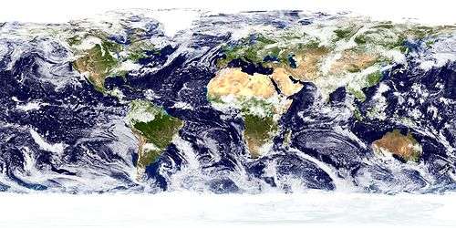
The International Satellite Cloud Climatology Project (ISCCP) was established as the first project of the World Climate Research Program (WCRP). Since its inception in 1982, there have been two phases, 1983–1995 and 1995–2009.[1] The project is responsible for collection and analysis of weather satellite radiance measurements. It infers clouds' global distribution and properties, along with their diurnal, seasonal, and interannual variations. The results are studied to understand clouds in climate, including their effects on radiative energy exchanges, plus their role in the global water cycle. These datasets provide a systematic view of cloud behavior.[2]
The ISCCP headquarters are located at the Goddard Institute for Space Studies in New York City.[3] ISCCP data is stored at the ISCCP Central Archive and at NASA. While the data are typically used for climate study, they are also a valuable resource for astronomical pursuits.[4]
From 1983, institutions from around the world have collected and analyzed satellite radiance measurements from two polar orbiting and five geostationary satellites.[1]
Objectives
The goals and objectives of the ISCCP have included:
- "Produce a global, reduced-resolution, calibrated and normalized, infrared and visible radiance dataset, along with basic information on the radiative properties of the atmosphere, from which cloud parameters can be derived.
- Coordinate basic research on techniques for inferring the physical properties of clouds from satellite radiance data.
- Derive and validate a global cloud climatology.
- Promote research using ISCCP data to improve parameterizations of clouds in climate models.
- Improve understanding of the earth’s radiation budget (top-of-atmosphere and surface) and hydrological cycle."[5]
Criticism
Some scientists suggest that the decreasing trends in the ISCCP data are "satellite viewing geometry artifacts" and the data may not be appropriate for some long-term global studies.[6]
See also
References
- 1 2 "International Satellite Cloud Climatology Project (ISCCP) Stage D1 3-Hourly Cloud Products - Revised Algorithm in Hierarchical Data Format (ISCCP_D1)". npolar.no. 2004-12-22. Retrieved 2008-10-13.
- ↑ "ISCCP OVERVIEW". nasa.gov. Retrieved 2008-10-13.
- ↑ "International Satellite Cloud Climatology Project (ISCCP) Data - C2". nerc.ac.uk. Retrieved 2008-10-13.
- ↑ "Global Cloud Cover Maps". umanitoba.ca. Retrieved 2008-10-13.
- ↑ "Accomplishments of the INTERNATIONAL SATELLITE CLOUD CLIMATOLOGY PROJECT". nasa.gov. Retrieved 2008-10-13.
- ↑ Evan, A. T.; A. K. Heidinger; D. J. Vimont (2007). "Arguments against a physical long-term trend in global ISCCP cloud amounts". Geophysical Research Letters. American Geophysical Union. 34 (L04701): L04701. Bibcode:2007GeoRL..3404701E. doi:10.1029/2006GL028083.
Further reading
- Tsuang, B.-J., Chou, M.-D., Zhang, Y., Roesch, A., & Yang, K. (2008). "Evaluations of Land-Ocean Skin Temperatures of the ISCCP Satellite Retrievals and the NCEP and ERA Reanalyses". Journal of Climate. 21 (2), 308-330. ISSN 0894-8755
- Knapp, K. R. (2008). "Calibration Assessment of ISCCP Geostationary Infrared Observations Using HIRS". Journal of Atmospheric and Oceanic Technology. 25 (2), 183-195. ISSN 0739-0572
- Evan, A. T., Heidinger, A. K., & Vimont, D. J. (2007). "Arguments against a physical long-term trend in global ISCCP cloud amounts (DOI 10.1029/2006GL028083)". GEOPHYSICAL RESEARCH LETTERS. 34 (4), L04701. ISSN 0094-8276
- Meinke, I. (2006). "A Comparison of Simulated Clouds to ISCCP Data". MONTHLY WEATHER REVIEW- USA. 134 (6), 1669-1681. ISSN 0027-0644
External links
- Official website
- Data sets
- FIRE (First ISCCP Regional Experiment)
- GIBBS (Global ISCCP B1 Browse System, 1974-2008)
- Monthly means