Ibex Valley
| Ibex Valley | |
|---|---|
|
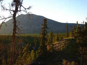
A view of the Ibex Valley | |
 Ibex Valley | |
| Long-axis direction | South - North and Southeast - Northwest |
| Long-axis length | 30 km (18.6 mi) |
| Width | 5 km (3.1 mi) |
| Depth | 500 m (1,640 ft) |
| Geography | |
| Coordinates | 60°43′06″N 135°23′07″W / 60.71833°N 135.38528°WCoordinates: 60°43′06″N 135°23′07″W / 60.71833°N 135.38528°W |
| Topo map | NTS 105D |
The Ibex Valley (named for Ibex Mountain) is located approximately 16 kilometres (9.9 mi) west of the City of Whitehorse, Yukon, Canada.[1] The valley, and surrounding area, is governed by five elected councilors from the Ibex Valley Hamlet. The population is rural with a mixture of farms and country residential.
The Ibex Valley is bounded by Ibex Mountain to the south; Mount Arkell and Mount Ingram to the west; Mount Sumanik and Mount Williams to the east.[1]
Description
The valley is generally undeveloped, with some recreational use trails. The vegetation consists of coniferous trees and grasslands [2] typically found in the sub-alpine ecosystem. The southern (higher) portion of the valley runs from south to north for about 15 km, at which point the axis of the valley turns to the northwest. This southeast - northwest section of the valley has a much shallower slope and the valley floor is wider.[1]
Surficial Geology
Generally, near surface geology of the valley consists of fluvial and glaciofluvial deposits of sand, gravel and silt units in the bottom of the valley. The valley sideslopes are made up of varying layers of colluvium and/or till moraines overlying bedrock. In some areas, the bedrock is exposed on the valley walls.
Land use
As the valley is mostly undeveloped, the land use is primarily recreational. Some trails exist. The trails are typically used for hiking, mountain biking,[3] bouldering,[4][5] cross country skiing, snow mobiling and dog sleding.[2]
Foothills Pipeline/Alaska Pipeline Project
In 1982, a pipeline right of way was granted to Foothills Pipeline Ltd (now a wholly owned subsidy of TransCanada Pipelines Limited) by the Northern Pipeline Agency. The proposed pipeline has undergone several name changes since the late '70s and is now called the Alaska Pipeline Project. The right of way travels through a portion of the Ibex Valley between the Alaska Highway near the Mendenhall subdivision and the north end of Fish Lake.
References
- 1 2 3 Whitehorse Yukon Territory NTS 105D (Map) (5 ed.). National Topographic System of Canada. § 105D. Retrieved 2012-03-03.
- 1 2 UMA Engineering Ltd., with David Hedmann & Associates, Burnaby, B.C. (November 1998), Hamlet of Ibex Valley Local Area Plan Plan Ibex (PDF)
- ↑ Hikes and Bikes Yukon
- ↑ Sierra, Allan. "Ibex Valley Bouldering Guide" (PDF). Retrieved 4 March 2012.
- ↑ "Bouldering Festival will rock Ibex Valley". Yukon News. 2008-07-25. Retrieved 4 March 2012.
External links
| Wikimedia Commons has media related to Ibex Valley. |