Independence State Airport
Coordinates: 44°52′01″N 123°11′54″W / 44.86694°N 123.19833°W
| Independence State Airport Independence Airpark | |||||||||||
|---|---|---|---|---|---|---|---|---|---|---|---|
 | |||||||||||
| IATA: none – ICAO: none – FAA LID: 7S5 | |||||||||||
| Summary | |||||||||||
| Airport type | Public | ||||||||||
| Owner | Oregon Department of Aviation | ||||||||||
| Serves | Independence, Oregon | ||||||||||
| Elevation AMSL | 180 ft / 55 m | ||||||||||
| Runways | |||||||||||
| |||||||||||
| Statistics (1999) | |||||||||||
| |||||||||||
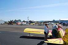
Independence State Airport (FAA LID: 7S5) is a public-use airport located one mile (1.6 km) northwest of the central business district of Independence, a city in Polk County, Oregon, United States. It is owned by the Oregon Department of Aviation.[1]
Serving as a general aviation airport, Independence also hosts a large residential airpark. This facility is Oregon's only Public Use airport hosting an airpark.
Facilities and aircraft

Independence State Airport covers an area of 83 acres (34 ha) which contains one runway designated 16/34 with a 2,935 x 60 ft (895 x 18 m) asphalt pavement. For the 12-month period ending October 18, 1999, the airport had 31,658 aircraft operations, an average of 86 per day: 96% general aviation and 4% air taxi. At that time there were 142 aircraft based at this airport: 94% single-engine, 2% multi-engine and 4% ultralight.[1] The Starduster Cafe on the airport serves breakfast, lunch, and dinner.
References
External links
- Independence State Airport Support Group
- Resources for this airport:
- FAA airport information for 7S5
- AirNav airport information for 7S5
- FlightAware airport information and live flight tracker
- SkyVector aeronautical chart for 7S5