Indiana State Road 103
| ||||
|---|---|---|---|---|
 | ||||
| Route information | ||||
| Maintained by INDOT | ||||
| Length: | 14.089 mi[1] (22.674 km) | |||
| Major junctions | ||||
| South end: |
| |||
| North end: |
| |||
| Location | ||||
| Counties: | Henry | |||
| Highway system | ||||
| ||||

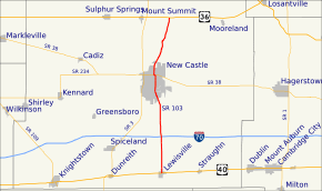
State Road 103 in the U.S. State of Indiana is a 14-mile (23 km) north–south route in Henry County.
Route description
State Road 103 nearly parallels its parent route, State Road 3, between U.S. Route 36 east of Mount Summit and U.S. Route 40 in Lewisville. It runs through downtown New Castle and past the Wilbur Wright Fish and Wildlife Area. It also crosses Interstate 70, but there is no interchange.[2]
History
SR 103 from US 40 to SR 38 was SR 3, before a new four-lane highway was built and SR 3 was rerouted onto the new four-lane highway.
Major intersections
The entire route is in Henry County.
| Location | mi[1] | km | Destinations | Notes | |
|---|---|---|---|---|---|
| Lewisville | 0.000 | 0.000 | Southern terminus of SR 103 | ||
| New Castle | 8.660 | 13.937 | Eastern end of SR 38 concurrency | ||
| 8.776 | 14.124 | Western end of SR 38 concurrency | |||
| Prairie Township | 14.089 | 22.674 | Northern terminus of SR 103 | ||
1.000 mi = 1.609 km; 1.000 km = 0.621 mi
| |||||
References
- 1 2 Indiana Department of Transportation (July 2015). Reference Post Book (PDF). Indianapolis: Indiana Department of Transportation. Retrieved September 17, 2016.
- ↑ Google (2007-09-19). "Indiana State Road 103" (Map). Google Maps. Google. Retrieved 2007-09-19.
External links
This article is issued from Wikipedia - version of the 11/8/2016. The text is available under the Creative Commons Attribution/Share Alike but additional terms may apply for the media files.