Indiana State Road 165
| ||||
|---|---|---|---|---|
 | ||||
| Route information | ||||
| Maintained by INDOT | ||||
| Length: | 17.2 mi[1] (27.7 km) | |||
| Major junctions | ||||
| South end: |
| |||
|
| ||||
| North end: |
| |||
| Location | ||||
| Counties: | Gibson, Posey | |||
| Highway system | ||||
| ||||

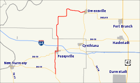
State Road 165 is a 17-mile (27 km) route in Gibson and Posey counties in the U.S. State of Indiana.
Route description
State Road 165 starts at State Road 66 near Wadesville then goes north through Poseyville where it intersects Interstate 64 at Exit 12. It is also concurrent with State Road 68 for about a mile in Poseyville. It then continues north before going east toward its parent route, State Road 65, at Owensville.
Major intersections
| County | Location | mi[1] | km | Destinations | Notes |
|---|---|---|---|---|---|
| Posey | Wadesville | 0.00 | 0.00 | Southern terminus of SR 165 | |
| Poseyville | 3.88 | 6.24 | Southern end of SR 68 concurrency | ||
| 4.83 | 7.77 | Northern end of SR 68 concurrency | |||
| 5.69 | 9.16 | Exit number 12 on I-64 | |||
| Gibson | Owensville | 17.19 | 27.66 | Northern terminus of SR 165 | |
1.000 mi = 1.609 km; 1.000 km = 0.621 mi
| |||||
References
- 1 2 "INDOT Roadway Referencing System" (PDF). Indiana Department of Transportation.
External links
This article is issued from Wikipedia - version of the 6/11/2016. The text is available under the Creative Commons Attribution/Share Alike but additional terms may apply for the media files.