Indiana State Road 237
| ||||
|---|---|---|---|---|
 | ||||
| Route information | ||||
| Maintained by INDOT | ||||
| Length: | 15.316 mi[1] (24.649 km) | |||
| Southern segment | ||||
| Length: | 5.370 mi[1] (8.642 km) | |||
| South end: |
| |||
| North end: |
| |||
| Northern segment | ||||
| Length: | 9.946 mi[1] (16.007 km) | |||
| South end: |
| |||
| Major junctions: |
| |||
| North end: |
| |||
| Location | ||||
| Counties: | Perry County, Crawford County | |||
| Highway system | ||||
| ||||

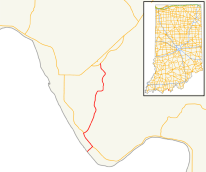
Indiana State Road 237 in the U.S. state of Indiana is a discontinuous route in Perry and Crawford counties.
Route description
Southern section
The Perry County segment of SR 237, which connects to SR 37 about 1-mile (1.6 km) northeast of Tell City, Indiana, provides access to Hawesville, Kentucky, via the Bob Cummings - Lincoln Trail Bridge in Cannelton. This segment of 237 is 5.6 miles (9.0 km) in length and replaced an older, winding and narrow segment in 2004.
Northern section
The Crawford County segment was created on November 21, 2007, when an 8.9-mile (14.3 km) segment of SR 37 from Interstate 64 at Sulphur to SR 64 at English was renumbered as SR 237. The redesignation is due to SR 37's designation being transferred to a new route (the Frank O'Bannon Highway) from I-64 to SR 64 and SR 145 between St. Croix and Eckerty.
Future
In addition, a proposed highway by-pass of Paoli, the seat of Orange County, may carry the SR 237 designation as well. This project is still in the planning stages and construction has yet to be scheduled.
Major intersections
| County | Location | mi[1] | km | Destinations | Notes | ||
|---|---|---|---|---|---|---|---|
| Ohio River | 0.000 | 0.000 | Bob Cummings Lincoln Trail Bridge; Indiana–Kentucky state line | ||||
| Continuation into Kentucky | |||||||
| Perry | Cannelton | 0.405 | 0.652 | ||||
| Troy Township | 5.370 | 8.642 | Northern terminus of the southern section of SR 237 | ||||
| Gap in route | |||||||
| Crawford | Sulphur | 5.371 | 8.644 | ||||
| Union Township | 6.313– 6.462 | 10.160– 10.400 | southern terminus of the northern section of SR 237 | ||||
| English | 15.242– 15.316 | 24.530– 24.649 | Northern terminus of SR 237 | ||||
| 1.000 mi = 1.609 km; 1.000 km = 0.621 mi | |||||||
References
- 1 2 3 4 Indiana Department of Transportation (July 2015). Reference Post Book (PDF). Indianapolis: Indiana Department of Transportation. Retrieved October 8, 2016.