Indiana State Road 462
| ||||
|---|---|---|---|---|
 | ||||
| Route information | ||||
| Maintained by INDOT | ||||
| Length: | 2.946 mi[1] (4.741 km) | |||
| Major junctions | ||||
| South end: | O'Bannon Woods State Park | |||
| North end: |
| |||
| Location | ||||
| Counties: | Harrison | |||
| Highway system | ||||
| ||||

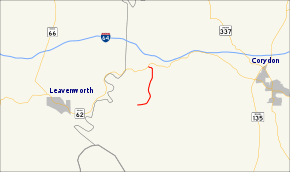
State Road 462 is a short three-mile (4.8 km) spur route in southwestern Harrison County, Indiana.
Route description
State Road 462 begins at State Road 62 and runs generally south through heavily wooded country. It crosses the Blue River just 0.02 miles (0.032 km) south of State Road 62 (which follows the line of the river here), and crosses Rock Creek after another 0.9 miles (1.4 km). It terminates at the O'Bannon Woods State Park and Cold Friday Road.
Major intersections
The entire route is in Harrison Township, Harrison County.
| mi[1] | km | Destinations | Notes | ||
|---|---|---|---|---|---|
| 0.000 | 0.000 | Northern terminus of SR 462 | |||
| 2.946 | 4.741 | O'Bannon Woods State Park | Southern terminus of SR 462 | ||
| 1.000 mi = 1.609 km; 1.000 km = 0.621 mi | |||||
References
- 1 2 Indiana Department of Transportation (July 2015). Reference Post Book (PDF). Indianapolis: Indiana Department of Transportation. Retrieved October 1, 2016.
This article is issued from Wikipedia - version of the 10/1/2016. The text is available under the Creative Commons Attribution/Share Alike but additional terms may apply for the media files.