Ingraham Glacier
| Ingraham Glacier | |
|---|---|
|
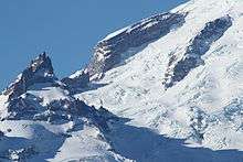
Climbing Ingraham Glacier, Little Tahoma Peak below | |
 Ingraham Glacier | |
| Type | Mountain glacier |
| Coordinates | 46°50′18″N 121°42′43″W / 46.83833°N 121.71194°WCoordinates: 46°50′18″N 121°42′43″W / 46.83833°N 121.71194°W[1] |
| Length | 2.6 mi (4.2 km) |
| Terminus | Icefall |
| Status | Retreating |

Ingraham Glacier is on the south-eastern flank of Mount Rainier, in the U.S. state of Washington. The glacier is named for the Mount Rainier enthusiast Edward Sturgis Ingraham.[2] From the summit ice cap, Ingraham Glacier flows east between Gibraltar Rock, (12,660 ft (3,860 m)), and Disappointment Cleaver and south of Little Tahoma Peak (11,138 ft (3,395 m)), which divides it from the much larger Emmons Glacier to the north. Descending southeast, it approaches the east flank of Cowlitz Glacier and the two glaciers nearly join at 6,700 ft (2,000 m).[3] Meltwater from the glacier drains into the Cowlitz River.
History
About 35,000 years ago, the Ingraham and Cowlitz glaciers flowed 62 mi (100 km) down from Mount Rainier to near present-day Mossyrock, Washington.[4] More recently, the Cowlitz - Ingraham glaciers advanced slightly from the mid-1970s to mid-1980s, but have been in a general state of retreat since the end of the Little Ice Age around the year 1850. During the Little Ice Age, the Ingraham and Cowlitz glaciers were combined and terminated at the 5,600-foot (1,700 m) level but have retreated more than 1 mi (1.6 km) in the last 150 years.
The worst mountaineering accident in American history occurred in on June 21, 1981, when eleven people lost their lives in an ice fall on the Ingraham Glacier. None of the bodies were ever recovered.[5]
See also
References
| Wikimedia Commons has media related to Ingraham Glacier. |
- ↑ "Ingraham Glacier". Geographic Names Information System. United States Geological Survey. Retrieved 2012-12-31.
- ↑ Majors, Harry M. (1975). Exploring Washington. Van Winkle Publishing Co. p. 125. ISBN 978-0-918664-00-6.
- ↑ Mount Rainier East, WA (Map). TopoQwest (United States Geological Survey Maps). Retrieved 2012-12-31.
- ↑ "Cowlitz and Ingraham Glaciers". Glaciers and Glacier Change. National Park Service. Retrieved 2012-12-31.
- ↑ Hatcher, Candy (March 30, 2000). "Ghosts of Rainier: Icefall in 1981 entombed 11 climbers". The Seattle Post-Intelligencer.