Inner Pierhead Fort
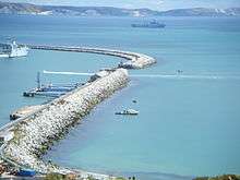
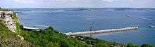
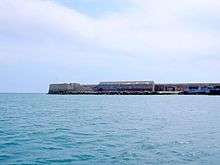
Inner Pierhead Fort is a Victorian fort built to defend Portland Harbour, at the Isle of Portland, Dorset, England. The fort is situated on the end of the inner breakwater, which abuts from the dockyard of the harbour, on the northern face of the island. It was constructed between 1859-1862, and is 100 ft in diameter. In September 1978 the inner breakwater became Grade II Listed, and this designation includes the fort.[1]
History
As part of the defence of Portland Harbour, the coastal artillery battery, Inner Pierhead Fort, was designed and built between 1859-62. Initially it was undecided on whether the fort should be built with Portland stone or granite. The army built two butt walls, one of Portland stone, and the other granite. HMS Blenheim used heavy fire upon these walls, and Portland stone proved to be stronger, and was chosen as the building stone.[2][3] In 1892 it was reported that the battery was armed with eight 64-pounder guns, and by 1902, two 12-pounder quick-firing guns were installed.[4] It was equipped with a 40 mm Bofors gun during World War II.[5]
As the 20th-century progressed the fort fell into total disuse and has never been opened to the public.[5] In 1996, the Royal Navy left Portland Harbour, and Portland Port Ltd became the new owners, turning the harbour into a commercial port. There were published reports that year revealing possible plans of the renovation of historic coastal fortifications in the area, however this never materialised for any of the harbour's historic sites, including the Inner Pierhead Fort.[6]
References
- ↑ Historic England. "Details from listed building database (1203106)". National Heritage List for England. Retrieved 28 September 2015.
- ↑ Morris, Stuart (2011). Dorset - The Royal Navy. Dovecote Press. pp. 26, 27. ISBN 978-1904349884.
- ↑ Legg, Rodney (1999). Portland Encyclopaedia. Dorset Publishing Company. p. 101. ISBN 978-0948699566.
- ↑ Historic England. "Monument No. 1425459". PastScape. Retrieved 28 September 2015.
- 1 2 Pomeroy, Colin A. (1995). Military Dorset Today: Second World War Scenes and Settings That Can Still Be Seen 50 Years On. Silver Link Publishing Ltd. p. 21. ISBN 978-1857940770.
- ↑ http://www.independent.co.uk/news/portlands-naval-history-ends-as-last-warship-sails-1592621.html
Coordinates: 50°34′09″N 2°25′20″W / 50.5691°N 2.4223°W