Microregion of Iporá
| Iporá | |
|---|---|
| Microregion | |
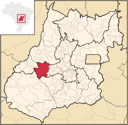 Location in Goias state | |
| Country | Brazil |
| State | Goiás |
| Mesoregion | Centro Goiano |
| Municipalities | 10 |
| Area | |
| • Total | 7,096.60 km2 (2,740.01 sq mi) |
| Population (2007) | |
| • Total | 58,845 |
| • Density | 8.3/km2 (21/sq mi) |
The Iporá Microregion is a geographical region in central-western Goiás state, Brazil.
Municipalities
The microregion consists of the following municipalities:[1]
| Municipality | Area (km²) | Inhabitants in 2007, July | Inhabitants in 2000 |
|---|---|---|---|
| Amorinópolis | 410 | 3,527 | 4.018 |
| Cachoeira de Goiás | 417 | 1,410 | 1,259 |
| Córrego do Ouro | 464 | 2,633 | 2,939 |
| Fazenda Nova | 1,286 | 6,373 | 7,832 |
| Iporá | 1,030 | 31,060 | 32,537 |
| Israelândia | 580 | 2,827 | 3,457 |
| Ivolândia | 1,267 | 2,718 | 3,184 |
| Jaupaci | 529 | 2,998 | 2,643 |
| Moiporá | 462 | 1,848 | 1,899 |
| Novo Brasil | 652 | 3,451 | 4,262 |
See also
References
- ↑ Instituto Brasileiro de Geografia e Estatística, territorial division.
Coordinates: 16°26′31″S 51°07′04″W / 16.44194°S 51.11778°W
This article is issued from Wikipedia - version of the 11/1/2016. The text is available under the Creative Commons Attribution/Share Alike but additional terms may apply for the media files.