Irisuna-jima
| Native name: <span class="nickname" ">入砂島 | |
|---|---|
|
Irisuna Island (below) and Tonaki Island (above) | |
 Irisuna-jima Location in Japan | |
| Geography | |
| Location | Tonaki, Okinawa Prefecture |
| Coordinates | 26°23′07″N 127°06′10″E / 26.385213°N 127.102684°ECoordinates: 26°23′07″N 127°06′10″E / 26.385213°N 127.102684°E |
| Area | 0.26 km2 (0.10 sq mi) |
| Highest elevation | 32 m (105 ft) |
| Administration | |
|
Japan | |
| Demographics | |
| Population | uninhabited |
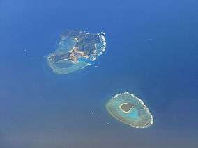
Irisuna-jima (入砂島), also known as Idesuna-jima (出砂島), is an uninhabited island in Tonaki, Okinawa Prefecture, Japan. It lies approximately four kilometres to the west of Cape Watanjisaki (ワタンジ崎), the northwest tip of Tonaki Island. Ceramics, including kamui ware and celadons, are evidence of human activity on the island over the longue durée. Public access is now prohibited since, under the designation FAC (Facilities Admin Code) 6078, Idesuna Jima Range (出砂島射爆撃場) is a live-fire training area for the United States Forces Japan.[1][2][3]
See also
References
- ↑ 入砂島 [Irisuna-jima] (in Japanese). Tonaki Village. Retrieved 16 November 2016.
- ↑ FAC6078出砂島射爆撃場 [FAC6078 Idesuna Jima Range] (in Japanese). Okinawa Prefecture. Retrieved 16 November 2016.
- ↑ 入砂島 [Irisuna Island]. Nihon Rekishi Chimei Taikei (in Japanese). Heibonsha. Retrieved 16 November 2016.
External links
This article is issued from Wikipedia - version of the 11/29/2016. The text is available under the Creative Commons Attribution/Share Alike but additional terms may apply for the media files.