Isla Bartolomé
For the island in the Galápagos, see Bartolomé Island.
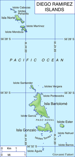 Isla Bartolomé is the largest of the Diego Ramírez Islands | |
 Isla Bartolomé Location of the archipelago | |
| Geography | |
|---|---|
| Coordinates | 56°32′S 68°43′W / 56.533°S 68.717°W |
| Archipelago | Diego Ramírez Islands |
| Area | 0.93 km2 (0.36 sq mi) |
| Highest elevation | 190 m (620 ft) |
| Administration | |
Isla Bartolomé is an uninhabited subantarctic island. Administratively it belongs to Chile.
Geography and ecology
With an area of 93 ha and a maximum height of 190 m (623 ft) it is the largest of the Diego Ramírez Archipelago, being more than twice the size of the second largest - Isla Gonzalo, lying in the Drake Passage between the continents of South America and Antarctica. It is an important breeding site for black-browed (over 35,000 pairs) and grey-headed (over 9000 pairs) albatrosses, as well as for southern giant petrels.[1][2]
 The island is an important breeding site for black-browed albatrosses |
See also
References
- ↑ "Island – Isla Bartolome". Island Group - Islas Diego Ramirez. Agreement on the Conservation of Albatrosses and Petrels. 2011. Retrieved 2011-07-21.
- ↑ Robertson, Graham; Moreno, Carlos A.; Lawton, Kieran; Arata, Javier; Valencia, Jose; Kirkwood, Roger. (2007). "An estimate of the population sizes of Black-browed (Thalassarche melanophrys) and Grey-headed (T. chrysostoma) Albatrosses breeding in the Diego Ramírez Archipelago, Chile". Emu. 107: 239–244. doi:10.1071/mu07028.
This article is issued from Wikipedia - version of the 11/11/2016. The text is available under the Creative Commons Attribution/Share Alike but additional terms may apply for the media files.