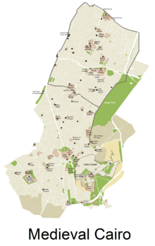
Islamic Cairo
| Historic Cairo | |
|---|---|
| Name as inscribed on the World Heritage List | |
 | |
| Type | Cultural |
| Criteria | i, v, vi |
| Reference | 89 |
| UNESCO region | Arab States |
| Inscription history | |
| Inscription | 1979 (3rd Session) |
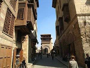
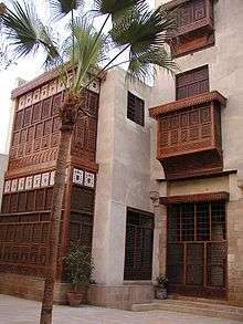
Islamic Cairo is a part of central Cairo noted for its historically important mosques and other Islamic monuments. It is overlooked by the Cairo Citadel.
History
Egypt was conquered by Arab Muslims under 'Amr ibn al-'As in 641. Alexandria was then the capital of Egypt. However, even though the Arabs admired Alexandria's glamor and wealth, they chose to establish a new capital on the east bank of the Nile. That site would not be separated by water from Medina, then the residence of the Caliph. Here, the 'Amr ibn al-'As Mosque was built, the first mosque in Africa. Later rulers added many additional mosques and palaces in the area around 'Amr Mosque.
Islamic Cairo, also referred to as Medieval Cairo or Fatimid Cairo, was founded in 969 as the royal enclosure for the Fatimid caliphs, while the actual economic and administrative capital was in nearby Fustat. Fustat was established by 'Amr ibn al-'As following the conquest of Egypt. Al-Askar, located in what is now Old Cairo, was the capital of Egypt from 750 to 868. Ahmad ibn Tulun established al-Qata'i as the new capital of Egypt, and it remained the capital until 905, when the Fustat once again became the capital. After Fustat was destroyed in 1168/9 to prevent its capture by the Crusaders, the administrative capital of Egypt moved to Cairo, where it has remained ever since. It took four years for the general Jawhar al-Siqilli (the Sicilian) to build Cairo and for the Fatimid Caliph al-Muizz to leave his old capital Mahdia in Tunisia and settle in the new Fatimid capital in Egypt.
After Memphis, Heliopolis, Giza and the Byzantine fortress of Babylon-in-Egypt, Fustat was a new city built as a military garrison for Arab troops. It was the closest central location to Arabia that was accessible to the Nile. Fustat became a regional center of Islam during the Umayyad period. It was where the Umayyad ruler, Marwan II, made his last stand against the Abbasids.
Later, during the Fatimid era, Al-Qahira (Cairo) was officially founded in 969 as an imperial capital just to the north of Fustat. Over the centuries, Cairo grew to absorb other local cities such as Fustat, but the year 969 is considered the "founding year" of the modern city.[1]
In 1250, the slave soldiers or Mamluks seized Egypt and ruled from their capital at Cairo until 1517, when they were defeated by the Ottomans. By the 16th century, Cairo had high-rise apartment buildings where the two lower floors were for commercial and storage purposes and the multiple stories above them were rented out to tenants.[2]
Napoleon's French army briefly occupied Egypt from 1798 to 1801, after which an Albanian officer in the Ottoman army named Muhammad Ali Pasha made Cairo the capital of an independent empire that lasted from 1805 to 1882. The city then came under British control until Egypt was granted its independence in 1922.
Today
Today, Islamic Cairo includes the Mosque of Ibn Tulun (the oldest and largest in Cairo), Al-Azhar University, the oldest university in the world, the Al-Hakim Mosque, and many other famous mosques and buildings.
Threats
Much of this historic area suffers from neglect and decay, in this, one of the poorest and most overcrowded areas of the Egyptian capital.[3] In addition, as reported in the Al-Ahram Weekly, thefts at Islamic monuments inside the Darb Al-Ahmar threaten their long-term preservation.[4]
See also
References
- ↑ Irene Beeson (September–October 1969). "Cairo, a Millennial". Saudi Aramco World. pp. 24, 26–30. Retrieved 2007-08-09.
- ↑ Mortada, Hisham (2003). Traditional Islamic principles of built environment. Routledge. p. viii. ISBN 0-7007-1700-5.
- ↑ Ancient Cairo: Preserving a Historical Heritage, Qantara, 2006.
- ↑ Unholy Thefts Al-Ahram Weekly, Nevine El-Aref, 26 June - 2 July 2008 Issue No. 903.
External links
 Media related to Islamic Cairo at Wikimedia Commons
 Islamic Cairo travel guide from Wikivoyage
Districts and suburbs of Greater Cairo | ||||||||||||||||
|---|---|---|---|---|---|---|---|---|---|---|---|---|---|---|---|---|
| Cairo Governorate |
| |||||||||||||||
| Giza Governorate |
| |||||||||||||||
| Qalyubia Governorate |
| |||||||||||||||
| ||
Coordinates: 30°02′45.61″N 31°15′45.78″E / 30.0460028°N 31.2627167°E