Buss Island
| Buss Island | |
|---|---|
|
Buss Island map from John Seller's "English Pilot" | |
| Created by | Martin Frobisher |
| Type | Phantom island |
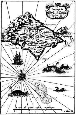

Bus, Buss, or Busse Island was a phantom island in the North Atlantic Ocean. It was recorded as discovered during the third expedition of Martin Frobisher in September 1578 by sailors aboard the ship Emanuel of Bridgwater (a "busse") and was indicated on maps as existing between Ireland and mythical Frisland at about 57° N. The island was then named for the type of vessel that its discoverers used.[2] It is believed that Frobisher took Greenland for Frisland and Baffin Island for Greenland and Emmanuel, returning home, made a mistake in dead reckoning and mistook optical effects near Greenland at around 62° N for a new land.
A Thomas Shepard claimed to have explored and mapped the island from Golden Lion of Dunkirk in 1671.[2] As Atlantic traffic increased, the island's existence was less certain and its supposed size was greatly reduced. By 1745, it was apparent there was no island at the site claimed and it was renamed the Sunken Land of Buss, as the supposed area was relatively shallow. The island or 'site of sunken island' persisted on charts into the 19th century. Its existence at the location was finally disproved by John Ross in Isabella in 1818 during his first Arctic expedition, finding no depth at 180 fathoms (330 m).[3]
References
- ↑ Dutch Nationaal Archief, Marine Maps archival inventory 4.MCAL inventorynumber 2134A http://proxy.handle.net/10648/7595c9dc-d178-836d-6480-e1fe3a394e63
- 1 2 Gosch, C.C.A. Danish Arctic Expeditions, 1605 to 1620. Book I.—The Danish Expeditions to Greenland in 1605, 1606, and 1607; to which is added Captain James Hall's Voyage to Greenland in 1612. "Appendix B. On 'Busse Island'." Hakluyt Society (London), 1897.
- ↑ "Sir John Ross at the Dictionary of Canadian Biography online". Retrieved 2008-12-02.