Israel River
Coordinates: 44°29′23″N 71°35′42″W / 44.4898°N 71.5951°W
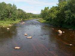
The Israel River (also called "Israel's River") is a river in the White Mountains of New Hampshire. It arises in the township of Low and Burbank's Grant and runs 24 miles (38 km) generally northwest along U.S. Highway 2, traversing the towns of Jefferson and Lancaster, before joining the Connecticut River. It is named for an early hunter, trapper and surveyor of the area, Israel Glines. The Johns River, in the nearby town of Whitefield, is named for Israel's brother John.
The Israel River rises near the foot of Mount Adams, at the juncture of Castle Brook and Cascade Brook. With its numerous tributaries, the river drains the northwestern slopes of Mount Adams and Mt. Jefferson in the Presidential Range, the northern slopes of the Dartmouth Range, and the southern slopes of the Pliny Range. The larger tributaries include the South Branch, The Mystic, Castle Brook, Cascade Brook, Stag Hollow Brook, Stanley Brook, Priscilla Brook, Alder Brook (also called Crawford Brook), Red Brook, Mill Brook, Garland Brook (which still turns a working saw mill) and Otter Brook.
Major highway bridges over the river include New Hampshire Route 115, U.S. Highway 2 and New Hampshire Route 115A in Jefferson, and U.S. Highway 3 on Main Street in Lancaster. A number of smaller bridges are provided for snowmobile trails, and there is an old covered bridge on Mechanic Street in Lancaster (closed in 2004 for major repairs and since reopened).
See also
References
- Julyan, Robert and Mary (1993). Place Names of the White Mountains (revised ed.). Hanover: University Press of New Hampshire. p. 77. ISBN 0-87451-638-2.
- USDA Forest Service (1993). White Mountain National Forest (Map).
- Museum of Science, Boston (Rev. 6/98). Mount Washington and the Heart of The Presidential Range (Map, 3d Ed). Boston: Globe Pequot Press, Inc. ISBN 0-910146-96-9. ("Israel's River").