Ivan Asen Point

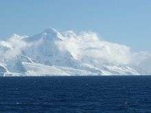

Ivan Asen Point (Bulgarian: Нос Иван Асен, ‘Nos Ivan Asen’ \'nos i-'van a-'sen\) is a narrow rocky point projecting 680 m into Osmar Strait from the southeast coast of Smith Island in the South Shetland Islands, Antarctica. It forms the southwest side of the entrance to Ivan Asen Cove and the northeast side of the entrance to Yarebitsa Cove, and separates the glacier termini of Dragoman Glacier to the north and Armira Glacier to the south.
The point is named after Czar Ivan Asen II of Bulgaria, 1218-1241 AD.
Location
The point is located at 63°01′43″S 62°31′09″W / 63.02861°S 62.51917°WCoordinates: 63°01′43″S 62°31′09″W / 63.02861°S 62.51917°W which is 12.5 km northeast of Cape James, 20.5 km southwest of Cape Smith, 3.8 km south-southeast of the island’s summit Mount Foster (2105 m), and 3.45 km southeast of Slaveykov Peak (Bulgarian mapping in 2009).
See also
Maps
- L.L. Ivanov. Antarctica: Livingston Island and Greenwich, Robert, Snow and Smith Islands. Scale 1:120000 topographic map. Troyan: Manfred Wörner Foundation, 2009. ISBN 978-954-92032-6-4
- Antarctic Digital Database (ADD). Scale 1:250000 topographic map of Antarctica. Scientific Committee on Antarctic Research (SCAR), 1993–2016.
References
- Ivan Asen Point. SCAR Composite Antarctic Gazetteer.
- Bulgarian Antarctic Gazetteer. Antarctic Place-names Commission. (details in Bulgarian, basic data in English)