Jabal Zambar
| Jabal Zambar | |
|---|---|
| جبل زمبر | |
 Jabal Zambar Tel Afar District of Nineveh Province of northern Iraq | |
| Highest point | |
| Elevation | 543 metres (1,781 ft) |
| Coordinates | 36°21′36″N 42°32′17″E / 36.36°N 42.538056°ECoordinates: 36°21′36″N 42°32′17″E / 36.36°N 42.538056°E [1] |
| Geography | |
| Location | Tel Afar District of Nineveh Province of northern Iraq |
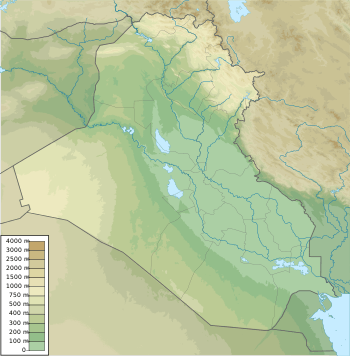
Jabal Zambar (Arabic: جبل زمبر) is a large hill in the Tel Afar District of Nineveh Province of northern Iraq. The name may also be rendered as Jabal or Jebel Sinbar, Zinbar or Zinbār, or Zambar Mountain.
Geography
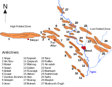
Jebel Zambar is in a transitional folded zone between the alpinotype area to the northeast and the Arabian Shield to the southwest.[2] This area holds the major anticlinal structures between the Tigris and the Al-Tharthar basin.[3] The zone includes Jebel Sinjar, Jebel Sinu, Jebel Sasan, Jebel Zambar, Jebel Sheik Ibrahim and Jebel Adaiya.[4] The Jebels Zambar and Ibrahim are sometimes treated as one structure.[5]
The Sanjar-Zambar mountain range includes the Teymurlenk (Tamerlane) hills, which contain the Turkmen city of Tal Afar.[6] Jabal Zambar is the highest point in the hilly area to the east of Tal Afar.[3] It is about 543 metres (1,781 ft) above sea level.[7] A shallow saddle to the northwest of Jebel Zambar divides it from the similar Jebel Sasan structure, which is about 10 by 7 kilometres (6.2 by 4.3 mi) in extent.[2]
History
In the late 1930s Germans drilled wells on the Zambar and Qusair structures west of Mosul towards Sinjar.[8] A feasibility study of the Mosul Dam project was to include a study of irrigating the northern catchment area of the Tharthar depression. This would include construction of a water supply tunnel under Jabal Zambar.[9] On 7 January 2006 twelve U.S, military personnel died when their UH-60 Blackhawk helicopter crashed on Zambar Mountain.[10][11]
References
Citations
- ↑ Jabal Zambar: Iraq, NGIA.
- 1 2 Journal of the Geological Society of Iraq 1976, p. 102.
- 1 2 Al-Sawaf 1977, p. 23.
- ↑ Acta Universitatis Carolinae: Geologica 1978, p. 130.
- ↑ Journal of the Geological Society of Iraq 1976, p. 101.
- ↑ Orhan Ketene 2007.
- ↑ Sitzungsberichte 1953, p. 392.
- ↑ Longrigg 1967, p. 81.
- ↑ Al-Sawaf 1977, p. 50.
- ↑ Plaque XIII - U.S. Army Women’s Foundation 2007, p. 10.
- ↑ Michael Ignatius Edwards.
Sources
- Acta Universitatis Carolinae: Geologica. Universita Karlova. 1978. Retrieved 2014-08-03.
- Al-Sawaf, Fakhri D.S. (July 1977). "HYDROGEOLOGY OF SOUTH SINJAR PLAIN NORTHWEST IRAQ" (PDF). University College London. Retrieved 2014-08-03.
- "Jabal Zambar: Iraq". National Geospatial-Intelligence Agency. Retrieved 2014-08-03.
- Journal of the Geological Society of Iraq. The Society. 1976. Retrieved 2014-08-03.
- Longrigg, Stephen Hemsley (1967). Oil in the Middle East: its discovery and development. issued under the auspices of the Royal Institute of International Affairs [by] Oxford U.P. Retrieved 2014-08-03.
- "Michael Ignatius Edwards". Retrieved 2014-08-03.
- Orhan Ketene (2007). "Turkmen and Turkmeneli" (PDF). Retrieved 2014-08-03.
- "Plaque XIII - U.S. Army Women's Foundation" (PDF). May 2007. Retrieved 2014-08-03.
- Sitzungsberichte. Abt. 1, Biologie, Mineralogie, Erdkunde und verwandte Wissenschaften. 1953.