Jackie Junction
| Jackie Junction Western Australia | |
|---|---|
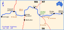 | |
| Jackie Junction location map | |
| General information | |
| Type | Road junction |
| Junction type | T-Junction |
| Location | Gibson Desert, 69 km (43 mi) north of Warburton |
| Opened | 16 August 1958 |
| Built by | Gunbarrel Road Construction Party |
| Roads at junction |
|
| |
Jackie Junction is a remote location in Western Australia on the Gunbarrel Highway. It was named by the road builder Len Beadell after his youngest daughter and is at the junction of the original Gunbarrel Highway and the road to Warburton. It is 69 kilometres (43 mi) north of Warburton.[1]
History
In May 1958 during survey work to determine the course of the Gunbarrel Highway, Beadell travelled through virgin scrub from Giles to Warburton, an existing Aboriginal mission station.[2] He selected the location approximately 65 kilometres (40 mi) north of Warburton as the commencement point for the next section of the Gunbarrel Highway. Survey westward from Jackie Junction took place from 14–28 May 1958, a road from Jackie Junction to Warburton was built in late August 1958, and construction of the final section of Gunbarrel Highway began on 3 September 1958 towards Carnegie Station. The road was completed on 15 November 1958.[3]
Gallery
-
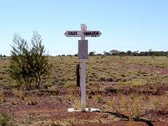
Signpost at Jackie Junction
-
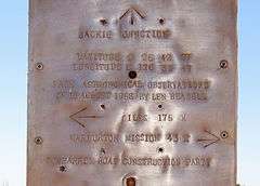
Detail of the plaque on the signpost
References
- ↑ Hema, Maps (2007). Australia Road and 4WD Atlas (Map). Eight Mile Plains Queensland: Hema Maps. p. 90. ISBN 978-1-86500-456-3.
- ↑ Bayly, Ian (2009). Len Beadell's Legacy. Seaford Vic 3198: Bas Publishing. p. 59. ISBN 9781921496028.
- ↑ Shephard, Mark (1998). A Lifetime in the Bush:The biography of Len Beadell. Adelaide: Corkwood Press. p. 234. ISBN 1876247053.