James River (Dakotas)
| James River | |
| Jim River, Dakota River | |
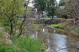 Flowing through Jamestown, North Dakota | |
| Name origin: French: Rivière aux Jacques | |
| Country | United States |
|---|---|
| States | North Dakota, South Dakota |
| Cities | Jamestown, ND, Aberdeen, SD, Huron, SD, Mitchell, SD, Yankton, SD |
| Source | Unnamed pond |
| - location | Wells County, North Dakota |
| - elevation | 1,871 ft (570 m) |
| - coordinates | 47°28′53″N 99°51′32″W / 47.48139°N 99.85889°W |
| Mouth | Missouri River |
| - location | Yankton County, near Yankton, South Dakota |
| - elevation | 1,152 ft (351 m) |
| - coordinates | 42°52′17″N 97°17′26″W / 42.87139°N 97.29056°WCoordinates: 42°52′17″N 97°17′26″W / 42.87139°N 97.29056°W |
| Length | 710 mi (1,143 km) |
| Basin | 20,942 sq mi (54,240 km2) |
| Discharge | for Scotland, SD |
| - average | 646 cu ft/s (18 m3/s) |
| - max | 29,400 cu ft/s (833 m3/s) |
| - min | 0 cu ft/s (0 m3/s) |
 The course and watershed of the James River. | |
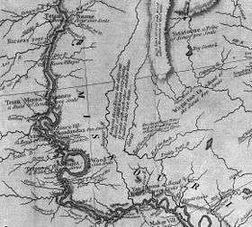
The James River (also known as the Jim River or the Dakota River) is a tributary of the Missouri River, approximately 710 miles (1,140 km) long, draining an area of 20,653 square miles (53,490 km2) in the U.S. states of North Dakota and South Dakota.[1] About 70 percent of the drainage area is in South Dakota.[2] The river provides the main drainage of the flat lowland area of the Dakotas between the two plateau regions known as the Coteau du Missouri and the Coteau des Prairies. This narrow area was formed by the James lobe of the Laurentide Ice Sheet during the last ice age, and as a consequence the watershed of the river is slender and it has few major tributaries for a river of its length.
The James drops approximately 5 inches (130 mm) per 1 mile (1.6 km), and this low gradient sometimes leads to reverse flow. Reverse flow occurs when high inflow from tributaries leads to James River water flowing upstream for several miles above the joining water. This happens most frequently north of Huron, South Dakota.[2]
The river arises in Wells County, North Dakota, approximately 10 mi (16 km) northwest of Fessenden. It flows briefly east towards New Rockford, then generally SSE through eastern North Dakota, past Jamestown, where it is first impounded by a large reservoir (the Jamestown Dam), and then joined by the Pipestem River. It enters northeastern South Dakota in Brown County, where it is impounded to form two reservoirs northeast of Aberdeen.
At Columbia, it is joined by the Elm River. Flowing southward across eastern South Dakota, it passes Huron and Mitchell, where it is joined by the Firesteel Creek. South of Mitchell, it flows southeast and joins the Missouri just east of Yankton.
The James River flows fully across the state of South Dakota, the only river other than the Missouri to do so.[2]
River conditions during normal years include still water on both the James and its tributaries as well as flooding. Floods occur after snowmelt or heavy rains, as water easily breaches the James' low banks, and such floods tend to cover a significant portion of the floodplain. When the river is still, water quality drops.[2]
History
Originally called "E-ta-zi-po-ka-se Wakpa," literally "unnavigable river", by the Dakota tribes, the river was named Rivière aux Jacques (literally, "James River" in English) by French explorers.[3] By the time Dakota Territory was incorporated, it was being called the James River. Thomas L. Rosser, a former Confederate general who helped to build the Northern Pacific Railroad across North Dakota. A Virginian, he named the settlement of Jamestown, North Dakota, after the English colony of Jamestown, Virginia. However, the Dakota Territory Organic Act of 1861 renamed it the Dakota River. The new name failed to attain popular usage and the river retains its pre-1861 name.
References
- ↑ http://waterdata.usgs.gov/nwis/nwisman/?site_no=06478500&agency_cd=USGS
- 1 2 3 4 Hogan, Edward Patrick; Fouberg, Erin Hogan (2001). The Geography of South Dakota (Third ed.). Sioux Falls, SD: The Center for Western Studies – Augustana College. ISBN 0-931170-79-6.
- ↑ Federal Writers' Project (1940). South Dakota place-names, v.3. University of South Dakota. p. 4.
See also
- List of longest rivers of the United States (by main stem)
- List of riversof North Dakota
- List of riversof South Dakota