Jaron Cliffs
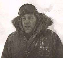
Helmut P. Jaron, for whom the Cliffs are named.
The Jaron Cliffs (76°23′S 112°10′W / 76.383°S 112.167°WCoordinates: 76°23′S 112°10′W / 76.383°S 112.167°W) are a line of steep, snow-covered cliffs on the south side of Mount Takahe, in Marie Byrd Land, Antarctica. They were mapped by the United States Geological Survey from ground surveys and U.S. Navy air photos, 1959–66, and were named by the Advisory Committee on Antarctic Names for Helmut P. Jaron, an aurora researcher at Byrd Station in 1963.[1]
References
- ↑ "Jaron Cliffs". Geographic Names Information System. United States Geological Survey. Retrieved 2012-07-17.
![]() This article incorporates public domain material from the United States Geological Survey document "Jaron Cliffs" (content from the Geographic Names Information System).
This article incorporates public domain material from the United States Geological Survey document "Jaron Cliffs" (content from the Geographic Names Information System).
This article is issued from Wikipedia - version of the 5/18/2014. The text is available under the Creative Commons Attribution/Share Alike but additional terms may apply for the media files.