Jean-Baptiste-Louis Franquelin
Jean-Baptiste-Louis Franquelin was born at Saint-Michel de Villebernin, France in 1650.[1] He died in France around 1712. He was a cartographer, a royal hydrographer, and a teacher of navigation. He was also the first official cartographer in Canada.
Biography
Between 1674 and 1708, Franquelin drew around 50 detailed illustrated manuscript maps of New France. Franquelin came to Canada as a trader in 1671. New France Governor Louis de Buade de Frontenac recognized his talents and recruited him to draw maps. He recorded the explorations of Louis Jolliet and René-Robert Cavelier de La Salle between 1674 and 1684. The King appointed him royal hydrographer in 1688. He went to France in 1692 to complete a series of maps on the New England coast. He had 13 children, but unfortunately, his wife and ten of his children drowned in a shipwreck in 1693, near of Sept-Iles, Quebec. He held his Canadian appointment from 1686 to 1697 and again from 1701 to 1703. However, from 1694 to 1707, he worked for Louis XIVth military engineer Vauban, and he never returned to Canada.[2]
Works (selection)
- Map of the Great Lakes[3]
- Carte du grand fleuve St Laurens dressee et dessignee sur les memoires et observations que le Sr. Jolliet a tres exactement faites en barq: et en canot en 46 voyages pendant plusieurs années[3][4] — Drawn with Louis Jolliet's collaboration
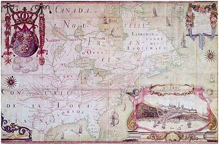
- Map of Louisiana,[5] 1684[6] — See also Google's presentation.
- Carte de France septentrionale[7]
- Maps on Wikimedia Commons
Lists of maps
- See Charbonneau, p. 46–52: 48 maps
- 34 maps at Newberry Library Cartographic Catalog
Notes and references
- ↑ Jean-Marie Germe, Bulletin des Amitiés Généalogiques Canadiennes-Françaises, no. 3, 1996. See also the online : record on fichierorigine.com.
- ↑ C.E Heidenrich, The Canadian Encyclopedia, second edition, volume II, Edmonton, Alberta: Hurtig Publishers, 1988, p. 839
- 1 2 On Gallica.
- ↑ When italicized, the name is the exact one.
- ↑ Library of Congress.
- ↑ Record, Newberry Library Cartographic Catalog.
- ↑ Derek Hayes. Historical Atlas of Canada: Canada's History Illustrated with Original Maps, p. 64.
- Burke-Gaffney, M. W. "Franquelin, Jean-Baptiste-Louis". In: Dictionary of Canadian Biography
- André Charbonneau. « Cartobibliographie de Jean-Baptiste-Louis Franquelin ». In: Papers of the Bibliographical Society of Canada, vol. 11, 1972, p. 39–52 (digital.library.mcgill.ca) — The list of maps is an attempt at exhaustivity.
- Biography at the Dictionary of Canadian Biography Online
- "Jean-Baptiste-Louis Franquelin". In: Canadian Encyclopedia
- Harrisse, H. (1872). Notes pour servir à l'histoire, à la bibliographie et à la cartographie de la Nouvelle-France et des pays adjacents, 1545–1700 (in French). Paris: Tross.
- Karel, David (1992). Dictionnaire des artistes de langue française en Amérique du Nord (in French). Presses de l'Université Laval, p. 314.
External links
| Wikimedia Commons has media related to Jean-Baptiste-Louis Franquelin. |