Jonsrud Viewpoint
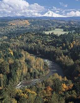 Jonsrud Viewpoint with Mount Hood in background and the Sandy River in the foreground | |
| Organization | City of Sandy, Oregon |
|---|---|
| Location | SE Bluff Road, Sandy, Oregon, U.S. |
| Coordinates | 45°24′37″N 122°16′25″W / 45.410288°N 122.273508°WCoordinates: 45°24′37″N 122°16′25″W / 45.410288°N 122.273508°W |
| Altitude | 856.2 feet (261.0 m)[1] |
Jonsrud Viewpoint is a viewpoint located in the city of Sandy in the U.S. state of Oregon. The viewpoint offers telescopes and expansive views of Mount Hood and the Sandy River Valley,[2] as well as the "Devil's Backbone," a ridge named by pioneers who were traveling on the Barlow Trail.[3] The site has been considered one of the "best views in Oregon."[4]
History
The viewpoint was named after Phil Jonsrud, a local historian in the city of Sandy.[5] Jonsrud, born in Kelso, was a war veteran who also spent time in New York City, though lived the majority of his life in Sandy. The offramp at the viewpoint was paved by the Jonsrud family.[5]
References
- ↑ Elevation Map Finder lists Jonsrud Viewpoint at 856.2 feet (261.0 meters)
- ↑ "Jonsrud Viewpoint". The Intertwine. Retrieved April 18, 2016.
- ↑ Gesch, Carrie (March 12, 2015). "Six Best Views of Mt. Hood". Travel Oregon. Retrieved April 9, 2016.
- ↑ "Thrilling overlooks and vistas". AAA Magazine; VIA Magazine. June 2011. p. 18. Retrieved April 12, 2016.
- 1 2 Fugetta, Emily (April 18, 2012). "Phil Jonsrud, man who chronicled Sandy history, dies at 93". The Oregonian. Retrieved April 18, 2016.
This article is issued from Wikipedia - version of the 11/22/2016. The text is available under the Creative Commons Attribution/Share Alike but additional terms may apply for the media files.