K-104 (Kansas highway)
| ||||
|---|---|---|---|---|
|
A map of the route and surrounding highways and towns. | ||||
| Route information | ||||
| Maintained by KDOT | ||||
| Length: | 2.275 mi[1] (3.661 km) | |||
| Existed: | 1967 – present | |||
| Major junctions | ||||
| South end: |
| |||
| North end: |
| |||
| Location | ||||
| Counties: | Saline | |||
| Highway system | ||||
| ||||

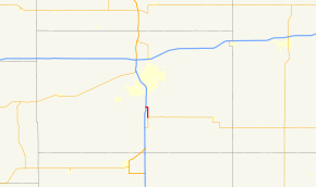
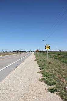
K-104 is a state highway in Saline County, Kansas. The route travels 2.3 miles (3.7 km) from a junction with K-4 to a junction with Interstate 135/U.S. Route 81 (I-135/US-81) at I-135 exit 86. It has an annual average daily traffic of between 1000 and 1300 and is paved with composite pavement. The highway is not a part of the National Highway System. The route was established around 1967, and has not been changed since.
Route description
The route begins in the south at a junction with K-4 near I-135/US-81.[2] It closely parallels I-135/US-81 through about 2 miles (3.2 km) of rural farmland before abruptly turning west at Smolan Road just west of Mentor.[3] After traveling west approximately 0.3 miles (0.48 km) the route ends at an interchange with I-135/US-81.[2] The route has a total distance of 2.3 miles (3.7 km), all of it in Saline County.[1][2]
The highway has an annual average daily traffic (the total volume of vehicle traffic of a highway for a year divided by 365 days) of 1,260 over the first 1 mile (1.6 km) of the route, and an AADT of 1,069 for the last 1.3 miles (2.1 km) of the route.[1] The entire route is paved with composite pavement.[1] K-104 is not a part of the National Highway System.[4]
History
The route was established around 1967 with its current routing in Saline County, with Interstate 135 signed as I-35W.[5][6] The routing has not been changed.[2]
Major intersections
The entire route is in Saline County.
| Location | mi[1] | km | Destinations | Notes | |
|---|---|---|---|---|---|
| | 0.000 | 0.000 | |||
| | 2.275 | 3.661 | Interchange | ||
| 1.000 mi = 1.609 km; 1.000 km = 0.621 mi | |||||
References
- 1 2 3 4 5 Staff (2010-06-24). "Pavement Management Information System Query". Kansas Department of Transportation. Retrieved 2011-08-14.
- 1 2 3 4 Kansas Official Transportation Map (PDF) (Map) (2011-2012 ed.). Cartography by Bureau Of Transportation Planning Cartography/GIS Unit. Kansas Department of Transportation. 2011. Retrieved 2011-08-14.
- ↑ Microsoft; Nokia (2011-08-14). "K-104" (Map). Bing Maps. Microsoft. Retrieved 2011-08-14.
- ↑ National Highway System (PDF) (Map). Kansas Department of Transportation. 2008. Retrieved 2011-08-19.
- ↑ Kansas Official Highway Map (PDF) (Map) (1966 ed.). State Highway Commission of Kansas. 1965. § C8. Retrieved 2011-08-14.
- ↑ Kansas Official Highway Map (PDF) (Map) (1967 ed.). State Highway Commission of Kansas. 1966. § C8. Retrieved 2011-08-14.
External links