Kaaimans River
| Kaaimans River | |
| Kaaimansrivier | |
| River | |
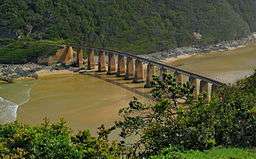 Tide coming up the estuary of the Kaaimans River | |
| Name origin: Named kaaiman after leguaan, a species of Monitor Lizard which was formerly found in the river.[1] | |
| Nickname: Keeromrivier | |
| Country | South Africa |
|---|---|
| Province | Western Cape |
| Region | Garden Route |
| Source | N of George |
| - location | Outeniqua Mountains |
| Mouth | Indian Ocean |
| - location | W of Wilderness, Western Cape |
| - elevation | 0 m (0 ft) |
| - coordinates | 33°59′52″S 22°33′25″E / 33.99778°S 22.55694°ECoordinates: 33°59′52″S 22°33′25″E / 33.99778°S 22.55694°E |
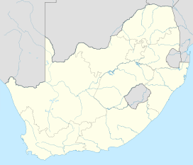 Location of the Kaaimans River mouth | |

The Kaaimans River (Afrikaans: Kaaimansrivier), also known as Keerom River, is a river in the Western Cape, South Africa. The mouth of the river lies near Wilderness.[2] Further upriver, the Kaaimans River Gorge is an ideal place for hiking and whitewater kayaking.[3]
The nearest large towns are Mossel Bay and George.
History
The Kaimaans River was formerly an obstacle for travellers, whose wagons had to wait sometimes for weeks before being able to cross it safely when it ran full of water. It was also nicknamed "Keeromrivier" (Turnabout River) because, faced with the raging waters, some travellers had to turn and try to find another way to reach their destination. Finally this obstacle was overcome when the Seven Passes Road was built by Thomas Charles John Bain.[4]
This river has a tidal estuary at its mouth that was crossed by a bridge, for the Outeniqua Choo Tjoe, the last passenger steam train in Africa that finally ended operation in June 2009.
See also
References
External links
| Wikimedia Commons has media related to Kaaimans River. |
- Wilderness’s Kaaimans river rescue
- Southern African Mountain Passes - Kaaimans River Pass
- Kaaimans River - Accommodation