Kadathur (Tiruppur)
| Kadathur | |
|---|---|
| Village | |
 Kadathur Location in Tamil Nadu, India | |
| Coordinates: 10°37′06″N 77°24′00″E / 10.61843°N 77.399956°ECoordinates: 10°37′06″N 77°24′00″E / 10.61843°N 77.399956°E | |
| Country |
|
| State | Tamil Nadu |
| District | Tirupur district |
| Elevation | 325 m (1,066 ft) |
| Population (2011) | |
| • Total | 3,056 |
| Languages Tamil, English | |
| • Official | Tamil |
| Time zone | IST (UTC+5:30) |
| PIN | 642203 |
| Telephone code | 04252 |
Kadathur (Tamil:கடத்தூர்) is a village in the Madathukulam Taluk of Tirupur district in the Indian state of Tamil Nadu. Earlier it was under Coimbatore District[1] Indian state of Tamil Nadu. It is situated on the banks of the river Amaravathi. It is a part of the "K" villages, namely, Kolumam, Kumaralingam, Karathozhuvu, Kadathur, Kannadiputhur, Karathozhuvu and kaniyur.
About the Village
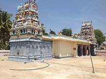
This village is surrounded by green fields, coconut groves and Marutha (Arjuna) Trees. This place is famous for the Arjuneswarar Temple. This temple's presiding Deity is Arjuneswarar, which is the tallest Swayambhu Lingam in the Kongu region of Tamil Nadu.
Connectivity
This village is situated approximately 20 km from Udumalaipettai and well connected by town buses.
References
- ↑ "New Tirupur district formed". The Hindu. Chennai, India. 2008-10-26.
External links
| State symbols |
|
|---|---|
| Governance |
|
| Topics | |
| Districts |
|
| Major cities | |